Go to the main content section Anchor point

New Taipei City Travel

Best Place for Children to Exert Energy- New Taipei Metropolitan Park

Anchor point
Best Place for Children to Exert Energy- New Taipei Metropolitan Park
Do you feel like your children have endless energy? And time seems to become slower when staying at home? There are lots of inclusive parks in New Taipei City that have new facilities different from the all similar facilities at traditional parks. You can enjoy facilities in different ways! The most popular "New Taipei Metropolitan Park" has the natural riverside view. A giant grassland is here for people to run, jog and jump. Besides, romantic installation art and interesting amusement facilities for kids can be found here. Mommy and Daddy, let's move! Bring your kids here to exert energy!

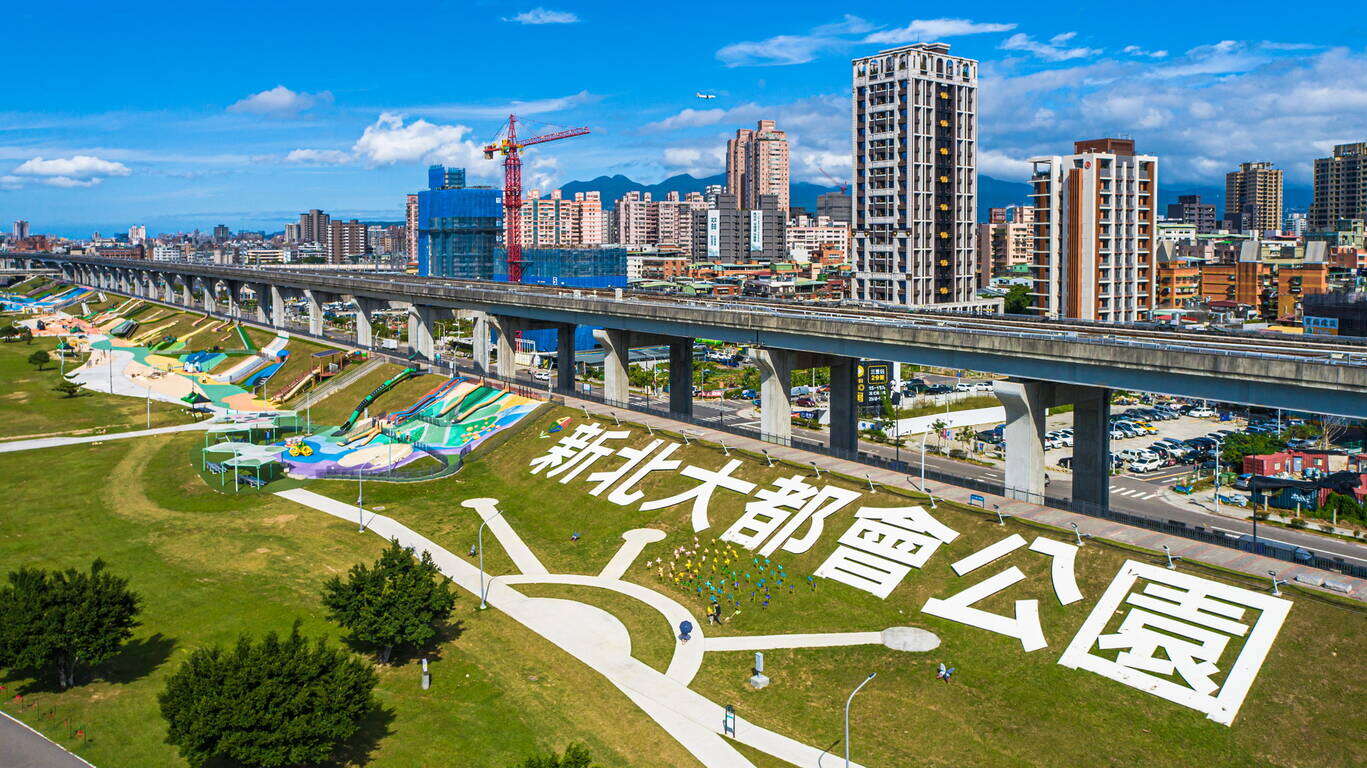
The New Taipei Metropolitan Park has an area of 424 hectares, which is 1.25 times bigger than the Central Park in New York City.
The New Taipei Metropolitan Park extends from the Wugu District, Luzhou District to Sanchong District with a length of 7.7 kilometers and a total area of 424 hectares. It is the biggest riverside sports park in New Taipei City. The area of the New Taipei Metropolitan Park equals to 16 Daan Parks in Taipei City and is 1.25 times bigger than the Central Park in New York City!

You will find 14 themed areas in the Park. Xingfu Shuiyang Park inside is an inclusive park and one of parents' favorites when it comes to taking children out. The transportation here is quite convenient. Take the MRT to "Sanchong Station" and you can walk to the Park. Besides, you can see the riverside view from height on the Chenguang Bridge next to the MRT Station. When at night, the romantic lighting will shine on the Bridge.

The Erchong Floodway used to be a flooding area. After treatment and organization, it has become a great park in the city. At the Park you will find a giant grassland where people can run to their hearts' content or have a picnic. What's more, the flower field that changes with seasons are right next to the riverside view. Large installation art that is great to take photos with will be established on a constant basis. The most incredible thing of the Park is the amusement facilities set up along the embankment. You can always see cute children playing on the facilities. The facilities make the Park an ideal place for kids.

The Super Exciting Slide of 7 Meter Height! Children Might Get Crazy When Just Entering the Park!
Let's take a look at the Park area that might get children crazy. When walking out of MRT Sanchong Station, you will first see slides on a grassland. With the combination with the slope landscape, 6 slides were built in colorful shades! If you look closely, you will see the slides can be separated into 2 layers. On the upper layer is the tube slides over 1-floor height. And you will find lots of people lining up for the slides since it's rare to have a chance for using slides this long for free. Follow the instruction on the ground to line up.

At the entrance of the slide is a flash notifier that will detect whether there are people at the exit below. Please follow the flash notifier to enjoy slides safely. There are 2 more curve slides on the upper layer, and they are longer and steeper. Therefore, the speed sliding down will be faster and people on slides will feel more excited! But before using the slides, you need to climb up first. Children can choose rock climbing, rope climbing, net climbing or taking stairs. Children seldom have the chance to climb using both hands and feet. It is challenging but a great way to train children's muscle!

The Simple, Safe, Barrier Free and Interactive Facilities Realize the Spirit of Inclusion!

On the lower layer are facilities for little kids. There are 2 curve slides here that are a lot shorter than the ones on the upper layer, and they are less dangerous. Moreover, at the end of the slide is a chair. Therefore, kids will not directly sit on the ground after sliding down, which is a lot safer. Next to these slides is the appealing terrazzo slide in a bowl shape. 2 slides are in the middle and around the slides are 2 half circle slopes. Children can sit side by side to slide down together. When sliding down, they can roll over at the same time. How fun is that!

Below are 2 pieces of other playground equipment: The climbing ball is very challenging. Children have to climb and weave in and out of the ball using their arm strength and balance skills at the same time. The other equipment is the swivel chair. Children can choose to sit inside or push it and run around it outside. They can cooperate with each other. The faster the swivel chair spins, the louder the laughter is. How joyful!

The whole playground is covered with colorful Polyurethane paving. The paving not only has a colorful and cute appearance, but is safer for the kids to run and jump in the Park. An instruction sign is set up next to each facility to remind people of safety notices while playing. Besides, the difficulty of how challenging the facilities are is written on the sign. Parents can pick the amusement facility based on children's age and physical strength to challenge your kids.

If you continue to walk along the embankment, you will see a giant artificial grass-skating field with the slope of 7 meters. The blue and white color scheme makes the field look like a waterfall. With the blue sky and a large area of green land, the scene is beautiful and comforting. In the middle of this section is the grass-skating area. The ground is covered by artificial turf and you can slide down from the slope with a grass-skating board or cardboard. How exciting it is! On both sides of the field is the climbing area where children can climb up on the bumpy slope. After a few times of climbing up and down, they will definitely be exhausted! A little reminder for parents: The Park is spacious and it can get very hot in summer time, remember to put on sunscreen and stay hydrated. The grass-skating field is suitable for children who are above the age of 5. When sliding down, make sure to keep some distances from the previous person and do not climb up from the grass-skating area in the middle to stay safe.

Holidays Only! FUN Park Train for Parents and Children!
Besides slides on the grass land and the grass-skating field like a waterfall, the "Embankment Slope Amusement Park" that was open in June 2020 is the latest highlight of the Park. The amusement park features animals in Taiwan is a must-visit!

The New Taipei Metropolitan Park is the largest riverside park in Taiwan. The Erchong Circular Biking Trail of about 20 kilometers is built within the Park. We recommend you to bring your family members to come here cycling on the Trail and feel the natural temperature with wind breezing on your face. Beautiful landscaping is right beside the Trail, so if you feel exhausted for too much cycling, stop the bike, take some photos and take a break. Or you can take New Taipei Metropolitan Park Train at Xinfu Station (across Chongxin Bridge Flea Market) on holidays. The Train circles the Park counter-clockwise and passes by MRT Sanchong Station, the Waterfall Grass-skating Field, Amusement Park and Love-telling Plaza on the way. The trip is about 30 minutes.

After seeing the introduction, I believe you feel like visiting the Park now! The New Taipei Metropolitan Park is definitely the best place for children to exert energy. We welcome you to bring your children and have fun here!

Nearby Places to Go
 

Gallery

Previous
The Xingfu Waterfront – Exploring New Taipei by cycling
The irrigation and water transportation provided by the river have nurtured countless civilizations and the rise of many big cities. The most important river in northern Taiwan, Tamsui River, supports more than 8 million residents in its basin. Going back in time to the 18th century, the center of the Greater Taipei area was Xinzhuang by the riverbank. "Xinzhuang Port crowded by thousands of sails, and the market lit by thousands of household lights" entails the reputation of prosperity that Xinzhuang enjoyed. In mid-19th century, Tamsui became an important international commercial port. However, due to river siltation and pollutions caused by rapid industrialization, Tamsui River was forgotten by residents. After years of improvement efforts, the riverside in New Taipei is once again a great place for citizens to enjoy relaxation and recreation.New Taipei City has a 1,382-hectare riverside park. Complete bicycle paths are made available along Tamsui River and its three tributaries—Dahan River, Xindian River, and Keelung River, with a total length of 210 kilometers, which is equivalent to the distance between Banqiao, New Taipei and Douliu, Yunlin! There are six major bicycle routes in New Taipei City, including Bali Left Bank, Golden Coast, Xizhi, Erchong Circular, Dahan River, and Xindian River. Hop on a bicycle and explore New Taipei from the waterfront at the speed of 15km per hour!(Map created by Water Resources Department, New Taipei City Government) Bali Left Bank Bicycle PathFrom Guanyinkeng Creek Estuary to Baxian Coast: 14 kilometers[Route] Guanyinkeng Creek Estuary -- Guandu Bridge -- Bali Ferry Dock -- Laorong Bunker -- Sustainable Development Education Center -- Bali Left Bank Park -- Waziwei Nature Reserve -- Bali Cultural Park-- Shihsanhang Museum of Archaeology -- Xiaguzi Fishing PortBali, located on the left bank of Tamsui River, is connected to Tamsui by ferries and Guandu Bridge across the wide Tamsui River. It is a port with a long history in New Taipei. Shisanhang Museum of Archaeology, an important archaeological site in Taiwan, is also located in this area. Cycling from the starting point of Guanyinkeng towards the estuary, you will see Guanyin Mountain on the left and Tamsui River on the right. On the way, you will pass by Guandu Bridge, Bali Ferry Dock Old Street, Shisanhang Museum of Archaeology, and other major attractions. Bali is also one of the top areas in terms of green space per capita. There are many inclusive parks along the route, such as Shanggang Park, Ferry Dock Park, Pianzigou Park, Shuixinggong Park, Shisanhang Cultural Park, and Bali Left Bank Park. The BALI landmark at Bali Left Bank Park is a popular social media photo spot.The casual atmosphere of Bali has brought many coffee shops here. Choose a coffee shop to spend a relaxed afternoon or visit Ferry Dock Old Street to taste the famous Shuangbaotai (fried pastry) and various fried seafood to satisfy your inner foodie!Golden Coast Cycling RouteFrom Guanhai Park to North Coast: 16.7 km[Route] Guanhai Park (the border between Taipei and New Taipei) -- Guandu Bridge -- Zhuwei Pier -- Mangrove Nature Reserve -- Golden Coast Riverside Park -- Tamsui Old Street -- Tamsui Ferry Dock -- Banyan Embankment -- Tamsui Customs Wharf Park -- Fisherman's Wharf -- Danhai New Town -- North CoastThere are many eateries on Tamsui Old Street. The most representative dish, A-gei, is made by hollowing out the middle of fried tofu, filling it with fried cellophane noodles, soaking it in a sauce, sealing it with fish paste, and finally serving it with a sweet and spicy sauce drizzled on top. It is a seemingly simple but unforgettably tasty dish.Xizhi BikewayFrom the border between Taipei and New Taipei to Wudu (towards Keelung): 9.8 km[Route] The border between Taipei and New Taipei -- Beishan Bridge -- Nanyang Bridge -- New Shehou Bridge -- Jiangbei Second Bridge -- Chengzhong Pumping Station -- Wudu Railway Station -- Wudu (towards Keelung)Xizhi, located at mid-stream Keelung River, was known as Shuifanjiao in the past. Situated between Taipei City and Keelung City, it is the most densely populated area on the east side of New Taipei City. Its early development was due to the rise of river transportation on Keelung River, in which Xizhi became an important distribution center for tea and other goods from the neighboring mountains. Keelung River is the most tortuous among the three tributaries of Tamsui River. You can feel the unique landscape of this river when cycling along the bank. The most eye-catching landmark of this bikeway is the Starlight Bridge that is shaped like a microphone. This single-tower, cable-stayed bridge is for pedestrians and bicycles only. Along the bikeway, there are major attractions such as Xizhi Old Street, Xizhi Jide Temple, and Wudu Tunnel Bicycle Path.Xizhi Night Market is a treasure trove of delicacies, including stinky tofu, Chinese angelica duck, shaved ice, ba-wan (Taiwanese meatballs), and Taiwanese fried chicken, waiting for you to discover.Erchong Circular BikewayOne lap of the bikeway: 20 kilometers[Route] Floodway Sports Park -- Xingfu Waterfront Park -- Floodway Lotus Park -- Floodway Waterfront Park -- Floodway Central Park -- Floodway Zhuifeng Park -- Floodway Marsh Park -- Floodway Canal Park – Floodway Luti Park -- Breeze Canal -- Floodway Ecological Park -- Tamsui Riverside Park -- Duckie Park -- Floodway Sports ParkErchong Floodway was part of the Greater Taipei Area Flood Control Plan. It connects with Tamsui River on the east side to form a circle that bounds Luzhou, Sanchong, and part of Wugu as an island, which connects to Xinzhuang, Wugu, and Taipei City by a dozen of bridges. One lap of Erchong Circular Bikeway is about 20 kilometers long. New Taipei City Government has planned a number of sports and entertainment venues at Erchong Floodway, including New Taipei Metropolitan Park, Xingfu Water park, Breeze Canal, and Chenguang Bridge, which is designed for pedestrians and bicycles only. Along Tamsui River, there is Sanchong Air Force Military Kindred Village No. 1, which is an important cultural asset of New Taipei. Anti-aircraft artillery positions and underground tunnels there have been preserved and now used as a shooting location for film crews.Sanhe Night Market next to MRT Taipei Bridge Station is where many eateries that have been in business for more than 30 years are, selling delicacies such as sesame oil chicken soup, wontons, ba-wan (Taiwanese meatballs), herbal tea, and papaya milk. They are great snacks after exercising. Dahan River BikewayFrom Left Bank - Taoyuan City border to Sanchong: 24.7 km[Route] Taoyuan City border -- Yingge Ceramics Museum -- Sanying Ceramics Park -- Ganyuan Riverside Park -- Shulin Riverside Environmental Park -- Lujiao Creek Constructed Wetland -- Xisheng Riverside Environmental Park -- Sanchong Riverside Environmental Park -- Floodway Sports ParkFrom Right Bank - Changfu Bridge to Huajiang Bridge: 19.5 km[Route] Changfu Bridge – Sanxia Bridge -- Sanjiaoyong Bridge -- Xibei Riverside Park -- Tucheng Environmental Park -- Tucheng Mazutian Riverside Park -- Fuzhou Sports Park -- Banqiao Environmental Park -- Fuzhou Arts Riverside Park -- Huajiang BridgeDahan River, formerly known as Dakekan River, is the longest tributary of Tamsui River. Its upper reach is the catchment area of Shimen Reservoir, which supplies water to Taoyuan City and the west side of New Taipei City. After entering New Taipei City, it passes through Yingge, Sanxia, Shulin, Tucheng, Xinzhuang, Sanchong, and finally merges into Tamsui River with Xindian River in Jiangzicui, Banqiao. The first section of Dahan River Bikeway is the heart of New Taipei City's art and creativity. Yingge Ceramics Museum and the upcoming New Taipei City Art Museum are here. The middle section passes through a number of ecologically rich wetland parks, such as Lujiao Creek Constructed Wetland, Fuzhou Constructed Wetland, and Xinhai Constructed Wetland. In the last section, you can find 435 Art Zone, which is suitable for families with children; and the most beautiful landmark on Dahan River, Crescent Bridge, which is the longest double-span steel arch bridge in Taiwan.Dahan River has deep culture and history. The most prosperous Xinzhuang Temple Street of Greater Taipei in mid-Qing Dynasty is still busy today. Xianguang cake, which is a temple street specialty is shaped like a bagel or donut with a mixed savory and sweet taste. It carries good blessings so you will be safe and sound after eating it. Sanxia Old Street is famous for its Baroque facade buildings and red brick archways, developed in late Qing Dynasty and the Japanese Rule period. The famous Golden Croissant also originated from the market of Sanxia. A variety of flavors and methods to enjoy them have been developed over time. It is a popular souvenir from Sanxia.Xindian River BikewayFrom Huajiang Bridge to Bitan Scenic Area: 16 km[Route] Huajiang Bridge -- Butterfly Park -- Yonghe Emerald Riverside Park -- Luguang Riverside Park -- Xiulang Bridge -- Xiulang Qingxi Park -- Sunshine Sports Park -- Qinqing Riverside Park -- Xindian BitanXindian River has high-quality water and is the hometown of Taiwan sweetfish. The upstream tributary, Beishi River, constitutes the most important reservoir supplying water to the Taipei Metropolitan Area, Feicui Reservoir. Xindian River Bikeway starts from Jiangzicui, Banqiao and ends at Bitan, Xindian. It passes through four major administrative districts, namely Banqiao, Zhonghe, Yonghe, and Xindian. There are many theme parks along the way, such as the popular social media photo spots Butterfly Park and Dinosaur Park. You can also visit Yang Sanlang Art Museum to learn about the development of modern art in Taiwan. In Xindian, you can find Sunshine Bridge of Xindian River that is exclusive to pedestrians and bicycles, as well as Bitan Scenic Area. The scenery here can be enjoyed day and night.Yonghe Soymilk, which originated from the Zhongzheng Bridge area of Yonghe, is now well-known at home as well as abroad. After visiting Yang Sanlang Art Museum, it is the perfect timing to visit the founding store to taste the rich and silky soymilk.Xingfu Waterfront is the most open area in the most densely populated city of Taiwan. Riding along the riverbank at a speed of 15km per hour in the breeze, after leaving the noisy concrete jungle, you will find the waterfront without cars or motorcycles as a quiet and calming path. At the same time, you will be delighted to find out that besides humans, there are many creatures living among us in this city. Hop on a bike, with a different vision and mood, set off to the waterfront!
Next
The Must-see Attraction for Foreign Visitors- the Yehliu Geopark
You only have a week in Taiwan and do not want to spend too much transportation time? Then you definitely cannot miss the "world-famous" tourist attraction- the Yehliu Geopark. I assume you have done your research on the must-see attraction that people are talking about before coming to Taiwan. Have you heard of the "alien planet" in the northern Taiwan? If no, please add it to your travel to-do-list. The Yehliu Geopark is located in the suburban area of Taipei City. It is 40 minutes away from downtown by public transportation. The long and narrow capes sticking out from the island are eroded by the strong northeast monsoon, and with the weathering and coastal erosion, the "Mars landscape" is thus generated. There are lots of rock types here and you can even see gradient colors on some of the rocks. The famous rocks will be introduced below. You will definitely be amazed when seeing the art of nature in person!Pedestal rock area/ wave-cut platform- 2 main characteristics of the GeoparkIn the first area, you will see lots of pedestal rocks, ginger shaped rocks and candle shaped rocks. When looking around, pedestal rocks are everywhere. With time passing by, the hard concretion inside the sandstone is exposed, and with the effect of wind, sun, rain, wave as well as the erosion of the northeast monsoon, the pedestal rocks of different shapes, such as the pedestal rocks with no necks, bulk necks, narrow necks and broken necks, are thus formed. The landscape with lots of pedestal rocks is very uneven, so pay attention while you are walking on it. Do not be too focused on taking photos or enjoying the view and fall.The second area on the other side of the Geopark has the wave-cut landscape. You will find sea caves, coastal notches, wave-cut platform and cuesta. On one side of the wave-cut platform is the cliff and on the other side is the rapid wave. You will find lots of interesting rocks eroded by the seawater here, including the Twenty-four Filial Exemplars Rocks.Landscape Wonder- The Pedestal RocksWhen first walking into the Geopark, you will see a huge area of the pedestal rocks. When seeing afar, it's like the cute mushrooms park. And the pedestal rocks are the landscape that attracts most people in the Yehliu Geopark. The process for the formulation of the pedestal rock is first the rock formation exposed from the sea surface, and the seawater will erode the rock continuously. After some time, the hard concretion inside the sandstone is exposed, and with the effect of wind, sun, rain, wave as well as the erosion of the northeast monsoon, the pedestal rocks of different shapes, such as the pedestal rocks with no necks, bulk necks, narrow necks and broken necks, are thus formed. The different shapes of the rocks represent the different formation processes. The landscape with lots of pedestal rocks is very uneven, so pay attention while you are walking on it. Do not be too focused on taking photos or enjoying the view and fall.The Star of the Geopark - "Queen's Head"The next coming up is the star of the Yehliu Geopark, "Queen's Head". The Queen's Head is a kind of pedestal rock. When the crustal structure was rising, the differential erosion of the seawater made the Queen's Head what it is like today. If we divide its height by the average crust rising speed in northern Taiwan, we will learn the Queen's Head is about 4,000 years old. The Queen's Head is a kind of pedestal rock. However, the joint on its upper concretion broke during 1962-1963. When viewing from a certain angle, it looks similar to the head portrait of Elizabeth II and thus acquires the name. With the natural weathering effect over the decades, the neck of the Queen's Head is getting even narrower. To prevent erosion by human activities for that tourists might touch it, the Queen's Head is now under protection. If you would like to take a photo with the Queen's Head, you can walk on the wooden plank trail to line up. Besides, you can view the Queen's Head from afar and take photos with it on the trail.The "Cute Princess Rock" and "Candle Shaped Rock" are the popular landscape at the Geopark. The formation process of the "Cute Princess Rock" is similar to that of the Queen's Head. The eroded rock looks like a princess with a ponytail and is said to be the potential replacement of the Queen's Head. Doesn't the rock look like a little girl with her hair in a bun? Though the Cute Princess Rock is probably not as element and sophisticated as the Queen's Head, it gives people a feeling of passion and sweetness.How was the "Candle Shaped Rock" named? I guess you already know! The landscape looks just like candles. There are 3 main processes for the formation of the Candle Shaped Rock. First the candle fire is exposed, and the area around it is eroded to form a groove. Finally, the candlestick is cut and the Candle Shaped Rock is thus formed. The candle fire is actually a round concretion in the rock formation. When seawater erodes sandstone, the round concretion which is harder is exposed on the ground. And when waves dash against the concretion, seawater flow around the concretion to erode the sandstone around it. A groove is formed as a result. Since the formation outside the concretion is harder, seawater will flow according to the shape of the formation and cut the rock into a cone shape that looks like a candlestick. And a rock that looks like the shape of candle is formed by mother nature.Amazing Rocks- CuestaNow let's look at the beautiful scene of the Cuesta in the second area. Walking along on the road to the Cuesta, you will see the most beautiful sea and mountain scene in the Geopark. You can view the Cuesta on one side and the sea cliff as well as wave-cut platform on the other side.The Cuesta features a sharp cliff on one side and a smooth slope on the other side. It is formed because the main stratum is pushed by uneven force and speed, which results in uneven rise of the stratum. When the stratum is pushed, the lump on the ground will cause the stratum to break. And after the seawater erosion, a landscape that looks like a "natural slide" is gradually formed.Guess how famous is the Yehliu Geopark? CNN once reported that the scene at the "Yehliu Geopark" is like the landscape in the outer space and that it has the environment that looks just like the one Mars has. You will definitely find lots of gorgeous and special rocks, including the "Queen's Head", "Ice Cream Rocks", "Beehive Rocks", "Ginger Shaped Rocks" and other wave-cut landscape. You will definitely be amazed by the diverse geologic structure and landscapes here. What's more, you can see how great and powerful nature is. Whether it's from the perspective of geographic environment or location and transportation, the Geopark is definitely worth visiting!Transportation Information of the Yehliu Geopark*Tamsui Bus No.862 (Take the bus heading to Keelung in front of MRT Tamsui Station and get off at Yehliu.) The bus sets out every 30 minutes.*KUO-KUANG eBus No. 1815 (Take the bus heading to Chinshan Youth Activity Center at the KUO-KUANG eBus Station at Taipei Main Station. The Bus drives along Zhongxiao E. Road and makes a brief stop at the Taipei City Hall Bus Station. Please get off at Yehliu.) The bus sets out every 20 minutes.*Keelung Bus No.790 (Take the bus heading to Jinshan next to Keelung Train Station and get off at Yehliu.) The bus sets out every 15 minutes.*Keelung Bus No.1068 (Take the bus heading to Jinshan at National Taiwan University and get off at Yehliu Geopark.)*Keelung Bus No.953 (Take the bus heading to Jinshan at the bus station next to Banqiao Train Station and get off at Yehliu Geopark.)Nearby Places to Go Jinshan Wanli Cycling Route-->Jinshan Wanli Hot Spring
Back to the top of page
小客帶路