Go to the main content section Anchor point

New Taipei City Travel

The Must-see Attraction for Foreign Visitors- the Yehliu Geopark

Anchor point
The Must-see Attraction for Foreign Visitors- the Yehliu Geopark
You only have a week in Taiwan and do not want to spend too much transportation time? Then you definitely cannot miss the "world-famous" tourist attraction- the Yehliu Geopark. I assume you have done your research on the must-see attraction that people are talking about before coming to Taiwan. Have you heard of the "alien planet" in the northern Taiwan? If no, please add it to your travel to-do-list. The Yehliu Geopark is located in the suburban area of Taipei City. It is 40 minutes away from downtown by public transportation. The long and narrow capes sticking out from the island are eroded by the strong northeast monsoon, and with the weathering and coastal erosion, the "Mars landscape" is thus generated. There are lots of rock types here and you can even see gradient colors on some of the rocks. The famous rocks will be introduced below. You will definitely be amazed when seeing the art of nature in person!

Pedestal rock area/ wave-cut platform- 2 main characteristics of the Geopark
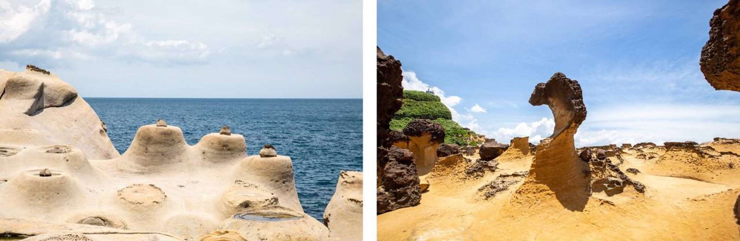
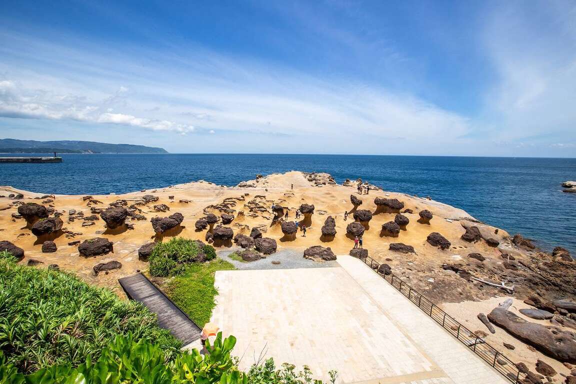
In the first area, you will see lots of pedestal rocks, ginger shaped rocks and candle shaped rocks. When looking around, pedestal rocks are everywhere. With time passing by, the hard concretion inside the sandstone is exposed, and with the effect of wind, sun, rain, wave as well as the erosion of the northeast monsoon, the pedestal rocks of different shapes, such as the pedestal rocks with no necks, bulk necks, narrow necks and broken necks, are thus formed. The landscape with lots of pedestal rocks is very uneven, so pay attention while you are walking on it. Do not be too focused on taking photos or enjoying the view and fall.

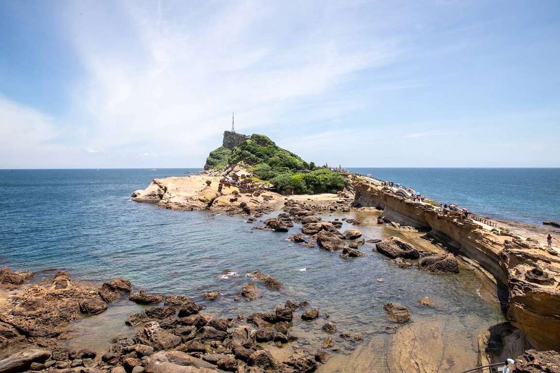
The second area on the other side of the Geopark has the wave-cut landscape. You will find sea caves, coastal notches, wave-cut platform and cuesta. On one side of the wave-cut platform is the cliff and on the other side is the rapid wave. You will find lots of interesting rocks eroded by the seawater here, including the Twenty-four Filial Exemplars Rocks.

Landscape Wonder- The Pedestal Rocks
When first walking into the Geopark, you will see a huge area of the pedestal rocks. When seeing afar, it's like the cute mushrooms park. And the pedestal rocks are the landscape that attracts most people in the Yehliu Geopark. The process for the formulation of the pedestal rock is first the rock formation exposed from the sea surface, and the seawater will erode the rock continuously. After some time, the hard concretion inside the sandstone is exposed, and with the effect of wind, sun, rain, wave as well as the erosion of the northeast monsoon, the pedestal rocks of different shapes, such as the pedestal rocks with no necks, bulk necks, narrow necks and broken necks, are thus formed. The different shapes of the rocks represent the different formation processes. The landscape with lots of pedestal rocks is very uneven, so pay attention while you are walking on it. Do not be too focused on taking photos or enjoying the view and fall.

The Star of the Geopark - "Queen's Head"
The next coming up is the star of the Yehliu Geopark, "Queen's Head". The Queen's Head is a kind of pedestal rock. When the crustal structure was rising, the differential erosion of the seawater made the Queen's Head what it is like today. If we divide its height by the average crust rising speed in northern Taiwan, we will learn the Queen's Head is about 4,000 years old. The Queen's Head is a kind of pedestal rock. However, the joint on its upper concretion broke during 1962-1963. When viewing from a certain angle, it looks similar to the head portrait of Elizabeth II and thus acquires the name. With the natural weathering effect over the decades, the neck of the Queen's Head is getting even narrower. To prevent erosion by human activities for that tourists might touch it, the Queen's Head is now under protection. If you would like to take a photo with the Queen's Head, you can walk on the wooden plank trail to line up. Besides, you can view the Queen's Head from afar and take photos with it on the trail.

    The "Cute Princess Rock" and "Candle Shaped Rock" are the popular landscape at the Geopark. The formation process of the "Cute Princess Rock" is similar to that of the Queen's Head. The eroded rock looks like a princess with a ponytail and is said to be the potential replacement of the Queen's Head. Doesn't the rock look like a little girl with her hair in a bun? Though the Cute Princess Rock is probably not as element and sophisticated as the Queen's Head, it gives people a feeling of passion and sweetness.

    How was the "Candle Shaped Rock" named? I guess you already know! The landscape looks just like candles. There are 3 main processes for the formation of the Candle Shaped Rock. First the candle fire is exposed, and the area around it is eroded to form a groove. Finally, the candlestick is cut and the Candle Shaped Rock is thus formed. The candle fire is actually a round concretion in the rock formation. When seawater erodes sandstone, the round concretion which is harder is exposed on the ground. And when waves dash against the concretion, seawater flow around the concretion to erode the sandstone around it. A groove is formed as a result. Since the formation outside the concretion is harder, seawater will flow according to the shape of the formation and cut the rock into a cone shape that looks like a candlestick. And a rock that looks like the shape of candle is formed by mother nature.

    Amazing Rocks- Cuesta
    Now let's look at the beautiful scene of the Cuesta in the second area. Walking along on the road to the Cuesta, you will see the most beautiful sea and mountain scene in the Geopark. You can view the Cuesta on one side and the sea cliff as well as wave-cut platform on the other side.

    The Cuesta features a sharp cliff on one side and a smooth slope on the other side. It is formed because the main stratum is pushed by uneven force and speed, which results in uneven rise of the stratum. When the stratum is pushed, the lump on the ground will cause the stratum to break. And after the seawater erosion, a landscape that looks like a "natural slide" is gradually formed.

    Guess how famous is the Yehliu Geopark? CNN once reported that the scene at the "Yehliu Geopark" is like the landscape in the outer space and that it has the environment that looks just like the one Mars has. You will definitely find lots of gorgeous and special rocks, including the "Queen's Head", "Ice Cream Rocks", "Beehive Rocks", "Ginger Shaped Rocks" and other wave-cut landscape. You will definitely be amazed by the diverse geologic structure and landscapes here. What's more, you can see how great and powerful nature is. Whether it's from the perspective of geographic environment or location and transportation, the Geopark is definitely worth visiting!

    Transportation Information of the Yehliu Geopark
    *Tamsui Bus No.862 (Take the bus heading to Keelung in front of MRT Tamsui Station and get off at Yehliu.) The bus sets out every 30 minutes.
    *KUO-KUANG eBus No. 1815 (Take the bus heading to Chinshan Youth Activity Center at the KUO-KUANG eBus Station at Taipei Main Station. The Bus drives along Zhongxiao E. Road and makes a brief stop at the Taipei City Hall Bus Station. Please get off at Yehliu.) The bus sets out every 20 minutes.
    *Keelung Bus No.790 (Take the bus heading to Jinshan next to Keelung Train Station and get off at Yehliu.) The bus sets out every 15 minutes.
    *Keelung Bus No.1068 (Take the bus heading to Jinshan at National Taiwan University and get off at Yehliu Geopark.)
    *Keelung Bus No.953 (Take the bus heading to Jinshan at the bus station next to Banqiao Train Station and get off at Yehliu Geopark.)

    Nearby Places to Go
    Previous
    The Xingfu Waterfront – Exploring New Taipei by cycling
    The irrigation and water transportation provided by the river have nurtured countless civilizations and the rise of many big cities. The most important river in northern Taiwan, Tamsui River, supports more than 8 million residents in its basin. Going back in time to the 18th century, the center of the Greater Taipei area was Xinzhuang by the riverbank. "Xinzhuang Port crowded by thousands of sails, and the market lit by thousands of household lights" entails the reputation of prosperity that Xinzhuang enjoyed. In mid-19th century, Tamsui became an important international commercial port. However, due to river siltation and pollutions caused by rapid industrialization, Tamsui River was forgotten by residents. After years of improvement efforts, the riverside in New Taipei is once again a great place for citizens to enjoy relaxation and recreation.New Taipei City has a 1,382-hectare riverside park. Complete bicycle paths are made available along Tamsui River and its three tributaries—Dahan River, Xindian River, and Keelung River, with a total length of 210 kilometers, which is equivalent to the distance between Banqiao, New Taipei and Douliu, Yunlin! There are six major bicycle routes in New Taipei City, including Bali Left Bank, Golden Coast, Xizhi, Erchong Circular, Dahan River, and Xindian River. Hop on a bicycle and explore New Taipei from the waterfront at the speed of 15km per hour!(Map created by Water Resources Department, New Taipei City Government) Bali Left Bank Bicycle PathFrom Guanyinkeng Creek Estuary to Baxian Coast: 14 kilometers[Route] Guanyinkeng Creek Estuary -- Guandu Bridge -- Bali Ferry Dock -- Laorong Bunker -- Sustainable Development Education Center -- Bali Left Bank Park -- Waziwei Nature Reserve -- Bali Cultural Park-- Shihsanhang Museum of Archaeology -- Xiaguzi Fishing PortBali, located on the left bank of Tamsui River, is connected to Tamsui by ferries and Guandu Bridge across the wide Tamsui River. It is a port with a long history in New Taipei. Shisanhang Museum of Archaeology, an important archaeological site in Taiwan, is also located in this area. Cycling from the starting point of Guanyinkeng towards the estuary, you will see Guanyin Mountain on the left and Tamsui River on the right. On the way, you will pass by Guandu Bridge, Bali Ferry Dock Old Street, Shisanhang Museum of Archaeology, and other major attractions. Bali is also one of the top areas in terms of green space per capita. There are many inclusive parks along the route, such as Shanggang Park, Ferry Dock Park, Pianzigou Park, Shuixinggong Park, Shisanhang Cultural Park, and Bali Left Bank Park. The BALI landmark at Bali Left Bank Park is a popular social media photo spot.The casual atmosphere of Bali has brought many coffee shops here. Choose a coffee shop to spend a relaxed afternoon or visit Ferry Dock Old Street to taste the famous Shuangbaotai (fried pastry) and various fried seafood to satisfy your inner foodie!Golden Coast Cycling RouteFrom Guanhai Park to North Coast: 16.7 km[Route] Guanhai Park (the border between Taipei and New Taipei) -- Guandu Bridge -- Zhuwei Pier -- Mangrove Nature Reserve -- Golden Coast Riverside Park -- Tamsui Old Street -- Tamsui Ferry Dock -- Banyan Embankment -- Tamsui Customs Wharf Park -- Fisherman's Wharf -- Danhai New Town -- North CoastThere are many eateries on Tamsui Old Street. The most representative dish, A-gei, is made by hollowing out the middle of fried tofu, filling it with fried cellophane noodles, soaking it in a sauce, sealing it with fish paste, and finally serving it with a sweet and spicy sauce drizzled on top. It is a seemingly simple but unforgettably tasty dish.Xizhi BikewayFrom the border between Taipei and New Taipei to Wudu (towards Keelung): 9.8 km[Route] The border between Taipei and New Taipei -- Beishan Bridge -- Nanyang Bridge -- New Shehou Bridge -- Jiangbei Second Bridge -- Chengzhong Pumping Station -- Wudu Railway Station -- Wudu (towards Keelung)Xizhi, located at mid-stream Keelung River, was known as Shuifanjiao in the past. Situated between Taipei City and Keelung City, it is the most densely populated area on the east side of New Taipei City. Its early development was due to the rise of river transportation on Keelung River, in which Xizhi became an important distribution center for tea and other goods from the neighboring mountains. Keelung River is the most tortuous among the three tributaries of Tamsui River. You can feel the unique landscape of this river when cycling along the bank. The most eye-catching landmark of this bikeway is the Starlight Bridge that is shaped like a microphone. This single-tower, cable-stayed bridge is for pedestrians and bicycles only. Along the bikeway, there are major attractions such as Xizhi Old Street, Xizhi Jide Temple, and Wudu Tunnel Bicycle Path.Xizhi Night Market is a treasure trove of delicacies, including stinky tofu, Chinese angelica duck, shaved ice, ba-wan (Taiwanese meatballs), and Taiwanese fried chicken, waiting for you to discover.Erchong Circular BikewayOne lap of the bikeway: 20 kilometers[Route] Floodway Sports Park -- Xingfu Waterfront Park -- Floodway Lotus Park -- Floodway Waterfront Park -- Floodway Central Park -- Floodway Zhuifeng Park -- Floodway Marsh Park -- Floodway Canal Park – Floodway Luti Park -- Breeze Canal -- Floodway Ecological Park -- Tamsui Riverside Park -- Duckie Park -- Floodway Sports ParkErchong Floodway was part of the Greater Taipei Area Flood Control Plan. It connects with Tamsui River on the east side to form a circle that bounds Luzhou, Sanchong, and part of Wugu as an island, which connects to Xinzhuang, Wugu, and Taipei City by a dozen of bridges. One lap of Erchong Circular Bikeway is about 20 kilometers long. New Taipei City Government has planned a number of sports and entertainment venues at Erchong Floodway, including New Taipei Metropolitan Park, Xingfu Water park, Breeze Canal, and Chenguang Bridge, which is designed for pedestrians and bicycles only. Along Tamsui River, there is Sanchong Air Force Military Kindred Village No. 1, which is an important cultural asset of New Taipei. Anti-aircraft artillery positions and underground tunnels there have been preserved and now used as a shooting location for film crews.Sanhe Night Market next to MRT Taipei Bridge Station is where many eateries that have been in business for more than 30 years are, selling delicacies such as sesame oil chicken soup, wontons, ba-wan (Taiwanese meatballs), herbal tea, and papaya milk. They are great snacks after exercising. Dahan River BikewayFrom Left Bank - Taoyuan City border to Sanchong: 24.7 km[Route] Taoyuan City border -- Yingge Ceramics Museum -- Sanying Ceramics Park -- Ganyuan Riverside Park -- Shulin Riverside Environmental Park -- Lujiao Creek Constructed Wetland -- Xisheng Riverside Environmental Park -- Sanchong Riverside Environmental Park -- Floodway Sports ParkFrom Right Bank - Changfu Bridge to Huajiang Bridge: 19.5 km[Route] Changfu Bridge – Sanxia Bridge -- Sanjiaoyong Bridge -- Xibei Riverside Park -- Tucheng Environmental Park -- Tucheng Mazutian Riverside Park -- Fuzhou Sports Park -- Banqiao Environmental Park -- Fuzhou Arts Riverside Park -- Huajiang BridgeDahan River, formerly known as Dakekan River, is the longest tributary of Tamsui River. Its upper reach is the catchment area of Shimen Reservoir, which supplies water to Taoyuan City and the west side of New Taipei City. After entering New Taipei City, it passes through Yingge, Sanxia, Shulin, Tucheng, Xinzhuang, Sanchong, and finally merges into Tamsui River with Xindian River in Jiangzicui, Banqiao. The first section of Dahan River Bikeway is the heart of New Taipei City's art and creativity. Yingge Ceramics Museum and the upcoming New Taipei City Art Museum are here. The middle section passes through a number of ecologically rich wetland parks, such as Lujiao Creek Constructed Wetland, Fuzhou Constructed Wetland, and Xinhai Constructed Wetland. In the last section, you can find 435 Art Zone, which is suitable for families with children; and the most beautiful landmark on Dahan River, Crescent Bridge, which is the longest double-span steel arch bridge in Taiwan.Dahan River has deep culture and history. The most prosperous Xinzhuang Temple Street of Greater Taipei in mid-Qing Dynasty is still busy today. Xianguang cake, which is a temple street specialty is shaped like a bagel or donut with a mixed savory and sweet taste. It carries good blessings so you will be safe and sound after eating it. Sanxia Old Street is famous for its Baroque facade buildings and red brick archways, developed in late Qing Dynasty and the Japanese Rule period. The famous Golden Croissant also originated from the market of Sanxia. A variety of flavors and methods to enjoy them have been developed over time. It is a popular souvenir from Sanxia.Xindian River BikewayFrom Huajiang Bridge to Bitan Scenic Area: 16 km[Route] Huajiang Bridge -- Butterfly Park -- Yonghe Emerald Riverside Park -- Luguang Riverside Park -- Xiulang Bridge -- Xiulang Qingxi Park -- Sunshine Sports Park -- Qinqing Riverside Park -- Xindian BitanXindian River has high-quality water and is the hometown of Taiwan sweetfish. The upstream tributary, Beishi River, constitutes the most important reservoir supplying water to the Taipei Metropolitan Area, Feicui Reservoir. Xindian River Bikeway starts from Jiangzicui, Banqiao and ends at Bitan, Xindian. It passes through four major administrative districts, namely Banqiao, Zhonghe, Yonghe, and Xindian. There are many theme parks along the way, such as the popular social media photo spots Butterfly Park and Dinosaur Park. You can also visit Yang Sanlang Art Museum to learn about the development of modern art in Taiwan. In Xindian, you can find Sunshine Bridge of Xindian River that is exclusive to pedestrians and bicycles, as well as Bitan Scenic Area. The scenery here can be enjoyed day and night.Yonghe Soymilk, which originated from the Zhongzheng Bridge area of Yonghe, is now well-known at home as well as abroad. After visiting Yang Sanlang Art Museum, it is the perfect timing to visit the founding store to taste the rich and silky soymilk.Xingfu Waterfront is the most open area in the most densely populated city of Taiwan. Riding along the riverbank at a speed of 15km per hour in the breeze, after leaving the noisy concrete jungle, you will find the waterfront without cars or motorcycles as a quiet and calming path. At the same time, you will be delighted to find out that besides humans, there are many creatures living among us in this city. Hop on a bike, with a different vision and mood, set off to the waterfront!
    Next
    Sanxia’s NTPU Special District
    Sanxia sits at the confluence of three streams and has served as an important water transportation hub since ancient times. From the mid-Qing Dynasty onward, it developed into a prosperous market town featuring baroque-style old streets and the Qingshui Zushi Temple, renowned as the "Oriental Art Palace." These represent the tangible manifestation of Sanxia's cultural depth.In the 1990s, College of Law and Commerce, National Chung Hsing University, established an independent institution in Sanxia, leading to the formation of the "Taipei University Special District." The NTPU Special District employs grid-pattern streets and green corridor planning to create spacious artistic pedestrian walkways. Combined with National Taipei University's beautiful campus environment, this shapes a livable atmosphere distinctly different from the old urban areas of Taipei and New Taipei, establishing a brilliant new highlight for Sanxia tourism. With the Sanying MRT Line's opening approaching, visiting the NTPU Special District for sightseeing will become even more convenient! National Taipei UniversityTaipei University, formerly the College of Law and Commerce, National Chung Hsing University, officially opened its new campus in Sanxia in 2000. This beautiful 60-hectare campus intentionally preserved many original landscape green spaces. "To see the lake is to see the heart" - "Heart Lake," named by Master Sheng Yen, sits at the campus center. The 2-hectare lake surface collects water from Liucuopu Canal and attracts numerous waterfowl and aquatic plants as residents. Walking around Heart Lake washes away urban clamor and allows quiet appreciation of the swans' graceful dance.(Campus map image source:National Taipei University)The central lawn surrounded by various college buildings and the library serves as National Taipei University's welcoming boulevard. Lush and open in atmosphere, it provides an excellent destination for family visits and picnicking. The campus's southwest corner borders Sanxia landmark Yuan Mountain, where the university established "Kite-Soaring Square" as a symbol of school spirit. The Sanying MRT Line bridge crossing above the Soaring Kite incorporates imitation brick arch design and bears the name "Nostalgic Corridor," where Sanxia's past and future interweave to create beautiful scenery.For travelers who appreciate architecture, the Library and Information Building along National Taipei University's central axis represents an unmissable campus landmark. With its owl-like wise appearance, multiple sky corridors connect the north and south reinforced concrete buildings. The modern and transparent design faces the central lawn to the east while offering views of Heart Lake and Yuanshan to the west.Distinctive Stores within NTPU CampusThe Amo Cake NTPU Practice Store serves as both the only creative space with painted walls at National Taipei University and a venue fully operated by students to practice entrepreneurial spirit. "NTPU Gorge Afternoon Tea" represents the NTPU Store's mountain journey to visit Sanxia tea farmers, carefully selecting hand-picked Biluochun green tea and honey-fragrant black tea, paired with classic Amo cakes in gift boxes. The packaging integrates local cultural heritage through Qingshui Zushi Temple design, showcasing youth creativity and local connections to create NTPU's most representative souvenir.Located on the second floor of Heart Lake Hall, Papershoot Café offers a rich variety of beverages and light meals. Visitors can also rent lightweight paper cameras from the establishment to experience the joy of shooting with four vintage filters. In the afternoon, enjoy delicious meals with friends in the coffee shop while using paper cameras to capture each other's smiles—both relaxing and thoroughly entertaining. NTPU Special District's Guinness World RecordOn Xueqin Road in front of National Taipei University's main gate stands a gleaming Guinness World Record monument, commemorating a burst of creativity in 2010! The mosaic creation project jointly organized by the NTPU Special District and Yingge Ceramics Museum successfully established the world record for "Most People Creating Mosaics Simultaneously," which remains a celebrated achievement.The NTPU Special District forms a livable living circle spanning Sanxia and Shulin. Walking along tree-lined Xueqin Road, visitors encounter mosaic creations made by children throughout the route. This 1.2-kilometer pedestrian art avenue allows appreciation of public art installations in Ocean Park and Shulin Wanping Park while experiencing the aesthetic lifestyle within the special district!NTPU Special District’s Distinctive StoresThe NTPU Special District has attracted many young new residents, bringing changes to food culture. Located on International First Street, Savor Bistro offers exquisite dishes including risotto, pasta, pizza, and steak meals, along with various cocktails. This comfortable space features resident singers and projection screens for sports events, making it a beloved dining destination for National Taipei University students and special district residents.Shabu Shabu Hotpot stands as the NTPU Special District's renowned hotpot establishment. Large floor-to-ceiling windows and garden landscaping create a spacious and transparent dining environment. Specializing in Japanese-style and Taiwanese-style broths, their high-quality meat melts in your mouth within five seconds of entering the boiling pot.NTPU Special District Annual EventsSince 2018, National Taipei University has planted hundreds of Yoshino cherry trees around Heart Lake. Every March when cherry blossoms bloom, they draw numerous visitors for cherry blossom viewing, establishing the area as Sanxia District's famous cherry blossom destination. University administration began organizing cherry blossom festivals in 2024, even bringing hot air balloons onto campus. Visitors can enjoy both cherry blossoms and hot air balloons, successfully generating tourism excitement for Sanxia.(Image source: National Taipei University)(Image source: National Taipei University) Sanxia is most celebrated for its Biluochun tea. National Taipei University collaborates annually with the New Taipei City Department of Agriculture to organize the Sanxia Green Tea Festival in picnic party format, combining Sanxia's high-quality Biluochun with food and agriculture education experiences. People gather for campus picnics, browse markets, and taste distinctive local teas.(Image source: National Taipei University)(Image source: National Taipei University)Every December, the NTPU Special District holds a Christmas lighting ceremony. As holiday decorations illuminate, the entire Xueqin Road and NTPU campus become instantly enveloped in romantic atmosphere, creating a winter-exclusive dreamlike scene. Stroll through the area and experience the NTPU Special District's rich Christmas spirit.(Image source: National Taipei University)
    Back to the top of page
    小客帶路