A Journey of Taking Beautiful Photos! A Thorough Visit to the Yinhe Cave and the Hongludi Nanshan Fude Temple with a Great Night View
Popularity 14.3k

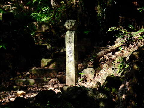
The Yinhe Cave Hiking Trail
Mt. Dailaokeng is the summit of the west extension belonging to the Ergeshan mountain range, it's also called Degaoling. The trail is flat and easy to hike and the landscapes along the way are lush and enticing. Dapianwei Ridge ends at Xindian River and Qingtan River, it's an easy hiking trail; along the way, there are the Yinhe Cave, Dachun Villa, etc, the lush scenes in front of the eyes are beautiful in a quiet atmosphere, a popular tourist's spot.
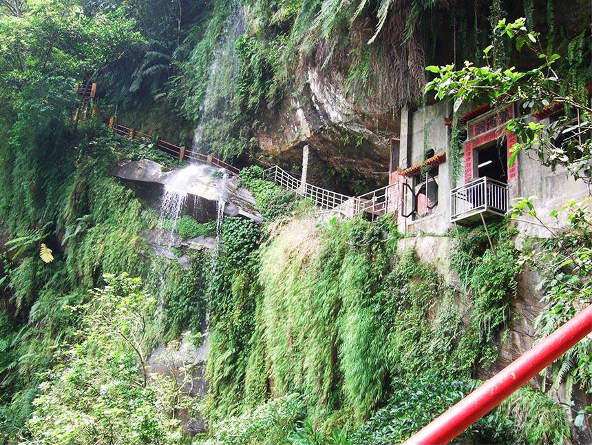
The Yinhe Cave is right beside Beiyi Road, it's a cave having an outline that curves inwards on the cliff; there's a small temple built to worship Guanyin. The words embossed on the cliff are "Bie-you-dong-tian (means a beautiful hidden spot)." When Meiziliao River reaches here, the waterfall drops at a 90-degree angle from the cliff and forms the Yinhe Cave Waterfall. Yinhe Cave was found in the Taisho 1 (in 1912), there's a Lu Dongbin Temple built behind it. Next to the temple, there are silk-like streams of water falling from the mountain; due to water tasting sweet and refreshing, a lot of tourists come here to scoop water and drink. Under the Yinhe Cave, there's a small garden with stone tables and chairs; tourists can admire the waterfall here while enjoying the chilly atmosphere that is filled with water splashes.
info.
Location and Address: Yinhe Rd., Xindian Dist., New Taipei City
Contact Phone Number: 886-2-29112281 (Xindian District Office)
Opening Hours: All year round.
Fax Number: 886-2-29670755
The traffic information from the MRT Xindian Station to the Yinhe Cave Hiking Trail
1. At the MRT Xindian Station, take the bus "Green Route 12" and get off at "Yinhe Cave".
2. At the MRT Dapingling Station, take the Bus No. "647" or "650" and get off at "Zhongsheng Bridge".
The Yinhe Cave Hiking Trail's information
Bitan Scenic Area
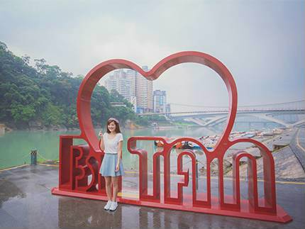
The “Bitan Scenic Area” is near the Taipei Metro Xindian Station. As part of the Xindian River, it is called “Bitan” (literally clear water lake) because water is clear, water flow is gentle, and the opening is spacious. In addition to the gentle slopes, beautiful mountains and the undulating bikeway suitable for lovers and family tours, the historical suspension bridge is the landmark of the scenic area.
On the bridge, the entire river and shore view of the “Bitan Scenic Area” is in sight. Below, visitors can surf around the lake in a water bike (aka swan boat), rent a bike to explore the gorgeous scenery of the area along the lakeside bikeway, or stroll across the romantic and exotic “Riverside Marketplace” to take pictures with the Cupid installation art and fun 3D paintings.
info.
Location and Address: Xindian District, New Taipei, Taiwan 231
Contact Phone Number: 886-2-29132579
Opening Hours: 8:00-17:00
The traffic information from the Yinhe Cave Hiking Trail to the Bitan Scenic Area
At Yinhe Cave", take the bus "Green Route 12" and get off at the MRT Xindian Station.
Bitan Scenic Area's information
Pompie 2
Located next to the No.4 Park, the owner of Pompie 2, who came back to Taiwan from Australia, hopes to introduce the authentic quiche to people, and he opened the Pompie, the previous name of Pompie 2. Afterwards, he reopened the shop with fresh flower smoothies and pieces of layer cake, and the shop's name was changed to Pompie 2. The signature flower smoothies are made of a mix of fresh fruit added with edible flowers and oats, not only healthy but also looking great in front of the camera. For sure, having the quiche for brunch is a must-eat food. The signature quiche layered by half-cooked sunny side up fried egg, pan-fried wild mushroom, salad, etc., really looking "Pompie (means abundant)"! In addition to the two kinds of food, there are pieces of layer cake, soft-serve milk ice cream, pudding, etc. available in Pompie 2. They are the best-selling desserts in summer.
info.
Location and Address: No.164, Anle Rd., Yonghe Dist., New Taipei City
Contact Phone Number: 886-2-89418148
Opening Hours: Weekdays: 1200~20:00; Holidays: 10:00~20:00; it closes on Tuesdays and from the 1st day to the 5th day of the 1st lunar month.
The traffic information from the Bitan Scenic Area to the Pompie 2
Take the MRT Xindian Line and get off at the Dapinglin Station; then, transfer to the Circular Line and get off at the Jingan Station. Or, transfer to the Zhonghe-Xinlu Line and get off at the Yongan Market Station. Walk through the 823 Memorial Park (No.4 Park). It takes about an 8-minute walk to reach the destination.
Pompie 2's information
Myanmar Street
Zhonghe is the home of huge immigrant population, including Burmese people who have settled down in Taiwan. A small market of Burmese food on Huaxin Street was formed after some Burmese immigrants decided to open Myanmar restaurants to satisfy their craving for the foods of their homeland. The market is now called Myanmar Street by local residents and has attracted not only Burmese Chinese, but also Taiwanese people, as food from Southeast Asian countries have become more and more popular in Taiwan. Some gourmands even visit this area only to find delicious and affordable delicacies from Southeast Asia, such as Guoqiao rice noodles, curry chicken, spicy rice noodles, lemon fish and milk tea. These dishes are sold at reasonable prices and you can relish them as they are prepared by nostalgic immigrants any time you want by yourself or with other people.
info.
Location and Address: Huaxin St., Zhonghe Dist., New Taipei City, Taiwan 235
Contact Phone Number: 886-2-22482688
Opening Hours: 08:00-18:00(Opening times based on individual shops)
The traffic information from the Pompie 2 to the Myanmar Street
Take the MRT the Zhonghe-Xinlu Line and get off at the Nanshijiao Station. It takes about a 10-minute walk to reach the destination.
Myanmar Street's information
Zhonghe Hongludi
Taiwan's biggest Earth God statue. Built over 260 years ago, Fude Temple in Nanshan is dedicated to the Earth God Fude Jhengshen. The temple's reputation and scale grew with a series of purported mystical signs. To thank the Earth God for his protection, the temple worshippers erected a 109-foot-tall statue in the deity's image.
info.
Location and Address: No.160-1, Ln. 399, Sec. 2, Xingnan Rd., Zhonghe Dist., New Taipei City, Taiwan 235
Contact Phone Number: 886-2-29425277
Opening Hours: Open all year round
The traffic information from the Myanmar Street to the Zhonghe Hongludi
At the Huaxin Street Station, take the Bus No.249 and get off at Hongludi. It takes about a 500-meter walk to reach the destination.
Zhonghe Hongludi's informaion
Return Trip Traffic Information
At the Hongludi Station, take the Bus No. 249 or 670 and get off at Jingxin Street. It takes a 450-meter walk to reach the MRT Nanshijiao Station.
Circular Line MAP