Go to the main content section Anchor point

New Taipei City Travel

Once upon a time there was a walled city — Exploring Fangqiao City and the four temples

Anchor point
Exploring Fangqiao City

When it comes to walled cities in Taiwan, the first places most people think of are Tainan City, Taipei City, and Hengchun Township. The gates of these cities, which were built by officials, still have their gates and even some of their walls, and some of them have had MRT stops named after them (Beimen [north gate] Station, Ximen [west gate] Station or the Taipei MRT line), and are a shared memory among present-day Taiwanese people. But did you know that there is also a walled city in Banqiao, the prime district of New Taipei City?

枋橋古城路標

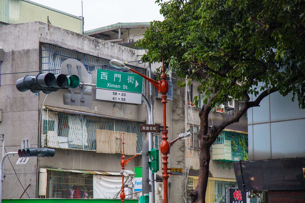
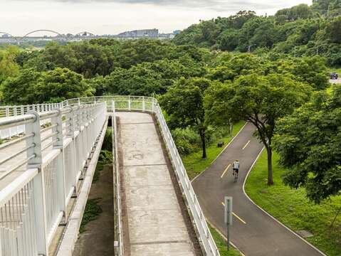
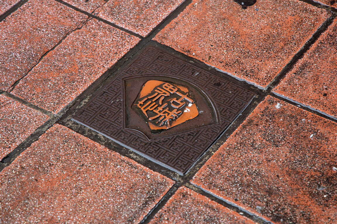
When going from the MRT Fuzhong Station to the Lin Family Mansion and Garden, perceptive travelers will notice that the streetlights in this area are particularly old fashioned, and that they are labelled “Fangqiao Walled City.” On top of that, when looking down, you can see the words “City Border” on the street tiles. The ancient Fangqiao Walled City had five city gates, just like Taipei; additionally, its history is even better known than that of Taipei, primarily due to two major factors that led to the establishment of the city: the Lin family of Banqiao and the Zhang-Quan fighting.
古城界址

Back in the Qing Dynasty, there were frequent fights between Zhangzhou and Quanzhou immigrants; in order to defend themselves from the Quanzhou immigrants, the Banqiao Lin family, who originally came from Zhangzhou, built the Fangqiao Walled City in 1855, stretching out to present-day Ximen [west gate] Street, Beimen [north gate] Street, Nanmen [south gate] Street, and Guanqian West Road. However, during the Japanese occupation, the city was demolished to make place for traffic. Nevertheless, the temples located in the area still show traces of the old city.
枋橋古城地圖

Cihui Mazu temple
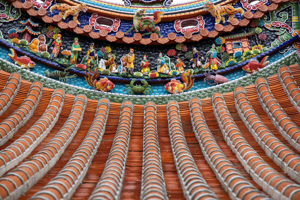
Located at the east side of the Fangqiao Walled City is the most popular Mazu temple in the Banqiao District. The temple is decorated on both the inside and the outside with fragmented ceramic art, sculptures, and color paintings, and the highly refined temple buildings are richly ornamented. In addition, the temple is a popular place for people to pray for prosperity, and local business magnates such as the Banqiao Lin family are all frequent visitors. If you look carefully, you can even find a dragon pillar bearing the business name of the Lin family.
慈雲宮屋頂剪粘
慈惠宮與板橋林家
慈惠宮財神

Banqiao Jieyun Temple
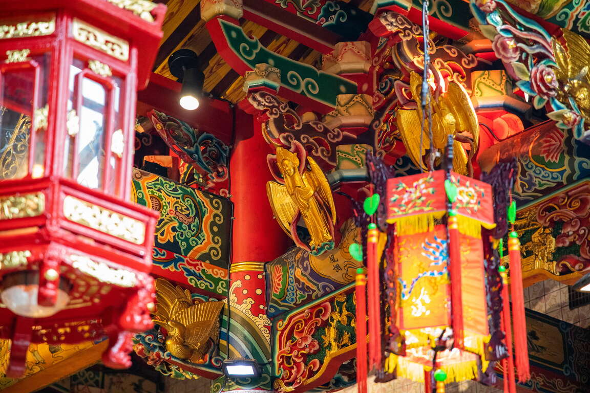
The Jieyun Temple and the Xinzhuang Dizang Temple, both located near the west gate of Fangqiao Walled City, are historically related to the Zhang-Quan fights; the Dizang Temple was built by the Banqiao gentry to commemorate the Zhangzhou people who died in the altercations. The Jieyun Temple, which is on the other side, was formerly known as the Zhonghe Ciyunyan Temple, but was destroyed during the armed struggles, and its remains were taken over by the Banqiao Jieyun Temple. Its collection contains many precious ancient plaques and scrolls, and there are many wood carvings of flying immortals wrapped in gold foil on both sides of the roof as well as in the main hall, which are very spectacular. The caisson ceiling has a special long oval design, and is of great historical and religious value.
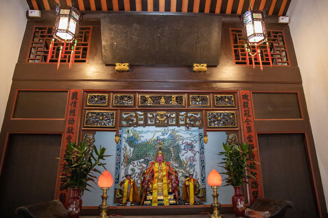
接雲寺金仙人
接雲寺藻井
大眾廟

Banqiao Diyi Temple
The only one of the four temples to have been a city-designated temple, the Diyi Temple, was built by the Banqiao Lin family to commemorate the people who died fighting; it is also known as the Yuanshuai Temple. In 2021, after it was restored, the temple opened up for the public by appointment. The paintings of the Door Gods and the Qilin murals inside are all made by master painter Mr. Cai Longjin, the winner of the New Taipei Cultural Award. Next time you are in Banqiao, on your way to the Lin Family Mansion and Garden, slow down and closely follow the inscriptions on the ground to explore the former Walled City, and enter the temples to admire the exquisite paintings and craftmanship, and explore the past life of the city!
迪毅堂
迪毅堂濕壁畫

Gallery

Previous
New Taipei’s Biking Paths: ONE to TEN
New Taipei City features rich and diverse landscapes, from the azure Route 2 Taiwan along the North Coast and the Leisurely Mountain and Sea Route that preserves mining heritage, to the riverside greenery in metropolitan areas. Each location offers unique scenery and stories. Hop on a bicycle and embark on low-carbon travel through New Taipei City at the most relaxing pace! New Taipei City has established Youbike public bicycle stations across all 29 administrative districts and extensively developed biking paths in tourist areas, making cycling adventures more convenient and safer. The Department of Tourism has carefully selected 10 biking paths. Let's ride from 1 to 10, One to Ten, and explore the diverse beauty of New Taipei City on two wheels!1. Wanjin Biking PathStart from Wanli's Green Bay and head toward Jinshan's Jhongjiao Bay! The Wanjin Biking Path stretches approximately 15 kilometers, featuring a route paved with asphalt and wooden boardwalks, accompanied by cooling shade and gentle sea breezes along the way. Visit attractions such as Shuiwei Fishing Harbor and Huangqing Bridge while admiring scenery that weaves together pastoral landscapes and azure coastlines. After working up a sweat on the Wanjin Biking Path, explore Jinshan Old Street to sample local delicacies. In the evening, stay at a hot spring hotel where a warm pool will completely melt away every trace of fatigue. 2. Shuangxi District Biking Path The Shuangxi District Biking Path spans approximately 6.2 kilometers, offering the joy of cycling through the lush green and fresh air of the Pinglin River basin. Starting from Shuangxi Train Station, visit attractions along the route including Shuangxi Lotus Garden, Ruanqiao Section Waterfront Park, the Lotus Garden in Lin Family’s Old House, and the Lian Scholar's Historic Residence. The Shuangxi District Biking Path provides smooth and easy riding, perfect for families cycling together. Beside crystal-clear streams, visitors can admire flowers, watch fish, and play in the water—the ideal choice for relaxation and enjoying nature. 3. Sandiao Cape (Old Caoling Belt Bikeway) Rent an e-bike from Fulong Station and enter the Old Caoling Belt Bikeway for a 20-kilometer journey through mountains and sea. First, enter the Old Caoling Tunnel where the music of "Diu Diu Dang Ah" plays as you travel from New Taipei through to Yilan. When that light at the tunnel's end transforms into the magnificent Pacific Ocean, ride along the mountain-and-sea biking path accompanied by Guishan Island to reach Taiwan's easternmost point: Sandiao Cape Lighthouse. Check in for stunning photos and admire the endless azure ocean. Continue your journey through the stone houses of Magang and Maoao fishing villages before finally returning to Fulong Station to feast on famous traditional Fulong lunch boxes. 4. Shimen (Wanta Biking Path, Shuangwan Biking Path) Shimen District serves as the central point of the Route 2 Taiwan and represents Taiwan's northernmost administrative district. Visit Shimen to see the landmark Shimen Cave and the main island's northernmost point at Fugui Cape, then follow the Wanta Biking Path connecting to the Shuangwan Biking Path. With sea breezes pushing you forward, cycle toward Baishawan and Qianshuiwan. By connecting the Wanta and Shuangwan Biking Paths for a 12-kilometer journey along wooden coastal boardwalks, you'll feast your eyes on the algae reef intertidal zone at Laomei Green Reef, the wind-carved rocks of Linshan Cape, and the pristine sandy beach of Baishawan! 5. Wugu (Erchong Circular Biking Path) The Erchong Floodway represents an important project under the Greater Taipei flood control plan. Its first phase was completed in 1984, significantly improving flood issues throughout the Tamsui River basin. The New Taipei City Government has successively developed multiple sports venues and recreational facilities within the Erchong Floodway, including New Taipei Metropolitan Park, and designed the Erchong Circular Biking Path. This circular route spans approximately 20 kilometers, crossing the administrative districts of Wugu, Luzhou, and Sanchong. Attractions along the way include Wugu Wetland Ecological Park, Breeze Canal, Air Force Sanchong Village 1, Chongxin Bridge Tourist Market, and New Taipei Metropolitan Park. 6. Lujiaoxi Wetland (Dahan River’s Left Bank Biking Path) Transformed from an abandoned landfill into a 16-hectare ecological paradise, Lujiaoxi Wetland serves as the water quality guardian of the Dahan River while providing habitat for migratory birds and aquatic plants. This area forms part of the Dahan River’s Left Bank Biking Path, which extends 24.7 kilometers total. Riding upstream leads to Yingge's New Taipei City Art Museum and Yuanshan Weir, while heading downstream through various major riverside wetlands takes you to Xinzhuang Temple Street and Crescent Bridge. This creates a waterfront cycling route that seamlessly blends art, culture, and ecology.7. Qixi Biking PathFormerly known as "Shuifanjiao," Xizhi sits between Taipei and Keelung. In earlier times, the prosperity of water transportation along the Keelung River led to the development of a thriving market town focused primarily on tea leaves and mountain goods distribution. The Keelung River is renowned for its winding and meandering terrain, and the Qixi Biking Path runs alongside this river. Stretching from Keelung's Qidu to New Taipei's Xizhi, the most striking landmark along the route is the microphone-shaped "Starlight Bridge." The Wudu Tunnel connecting Xizhi and Qidu is an old Taiwan Railway tunnel built during the Japanese colonial period. This brick-constructed arched tunnel has been restored to reveal its former glory, and cycling through it allows direct travel from New Taipei's Xizhi to Keelung! 8. Bali Left Bank Biking Path Located on the left bank of the Tamsui River estuary, Bali offers expansive views where river meets sea, making it ideal for leisurely cycling exploration. Follow the Bali Left Bank Biking Path for a relaxing ride, starting from Guanyinkeng, passing beneath the rainbow-like Guandu Bridge and through the food-rich Ferry Pier Old Street, all the way to Taiwan's first archaeological museum: The Shihsanhang Museum of Archaeology. Parks and green spaces dot the route, with the red "BALI" landmark set against the Tamsui River serving as a favorite check-in spot for social media enthusiasts. In the afternoon, choose a café to rest with a cup of left bank coffee, or visit the old street for crispy twin dough and fried seafood while savoring Bali's leisurely pace of life.9. JiufenCycling to Jiufen presents a challenging mountain-crossing adventure. Follow Municipal Route 102 starting from Ruifang, pushing upward along winding mountain roads toward the golden mountain city on the hillside. Upon reaching Jiufen, explore the old street, sip tea, and enjoy scenic views. If energy permits, continue along Route 102 toward Shuangxi. The highway features rolling mountains with expansive views, offering distant glimpses of Keelung Mountain, Jinguashi, and the North Coast. At Buyan Pavilion, named after Li Bai's poem verse "gazing at each other without growing tired," admire the straight road leading toward a sea of clouds.Jiufen live webcam showcases the beauty of this mountain town and provides current weather conditions. 10. Shifen Follow Municipal Route 106 into Pingxi, this coal-producing town located in the upper reaches of the Keelung River that has become world-famous for its sky lanterns. Cycle to visit railway towns along the route: Qingtong, Pingxi, Lingjiao, Wanggu, and Shifen, where you'll frequently witness sky lanterns carrying wishes rising gently into the sky. Cross the Siguangtan Suspension Bridge and Guanpu Suspension Bridge to admire the unique pothole geological formations in the Keelung River valley and the graceful water lines of Yanjingdong Waterfall, before finally reaching Taiwan's largest waterfall - Shifen Waterfall, where you can fully absorb negative ions. The Shifen Waterfall live webcam captures the waterfall's magnificent power and provides current weather conditions
Next
The Must-see Attraction for Foreign Visitors- the Yehliu Geopark
You only have a week in Taiwan and do not want to spend too much transportation time? Then you definitely cannot miss the "world-famous" tourist attraction- the Yehliu Geopark. I assume you have done your research on the must-see attraction that people are talking about before coming to Taiwan. Have you heard of the "alien planet" in the northern Taiwan? If no, please add it to your travel to-do-list. The Yehliu Geopark is located in the suburban area of Taipei City. It is 40 minutes away from downtown by public transportation. The long and narrow capes sticking out from the island are eroded by the strong northeast monsoon, and with the weathering and coastal erosion, the "Mars landscape" is thus generated. There are lots of rock types here and you can even see gradient colors on some of the rocks. The famous rocks will be introduced below. You will definitely be amazed when seeing the art of nature in person!Pedestal rock area/ wave-cut platform- 2 main characteristics of the GeoparkIn the first area, you will see lots of pedestal rocks, ginger shaped rocks and candle shaped rocks. When looking around, pedestal rocks are everywhere. With time passing by, the hard concretion inside the sandstone is exposed, and with the effect of wind, sun, rain, wave as well as the erosion of the northeast monsoon, the pedestal rocks of different shapes, such as the pedestal rocks with no necks, bulk necks, narrow necks and broken necks, are thus formed. The landscape with lots of pedestal rocks is very uneven, so pay attention while you are walking on it. Do not be too focused on taking photos or enjoying the view and fall.The second area on the other side of the Geopark has the wave-cut landscape. You will find sea caves, coastal notches, wave-cut platform and cuesta. On one side of the wave-cut platform is the cliff and on the other side is the rapid wave. You will find lots of interesting rocks eroded by the seawater here, including the Twenty-four Filial Exemplars Rocks.Landscape Wonder- The Pedestal RocksWhen first walking into the Geopark, you will see a huge area of the pedestal rocks. When seeing afar, it's like the cute mushrooms park. And the pedestal rocks are the landscape that attracts most people in the Yehliu Geopark. The process for the formulation of the pedestal rock is first the rock formation exposed from the sea surface, and the seawater will erode the rock continuously. After some time, the hard concretion inside the sandstone is exposed, and with the effect of wind, sun, rain, wave as well as the erosion of the northeast monsoon, the pedestal rocks of different shapes, such as the pedestal rocks with no necks, bulk necks, narrow necks and broken necks, are thus formed. The different shapes of the rocks represent the different formation processes. The landscape with lots of pedestal rocks is very uneven, so pay attention while you are walking on it. Do not be too focused on taking photos or enjoying the view and fall.The Star of the Geopark - "Queen's Head"The next coming up is the star of the Yehliu Geopark, "Queen's Head". The Queen's Head is a kind of pedestal rock. When the crustal structure was rising, the differential erosion of the seawater made the Queen's Head what it is like today. If we divide its height by the average crust rising speed in northern Taiwan, we will learn the Queen's Head is about 4,000 years old. The Queen's Head is a kind of pedestal rock. However, the joint on its upper concretion broke during 1962-1963. When viewing from a certain angle, it looks similar to the head portrait of Elizabeth II and thus acquires the name. With the natural weathering effect over the decades, the neck of the Queen's Head is getting even narrower. To prevent erosion by human activities for that tourists might touch it, the Queen's Head is now under protection. If you would like to take a photo with the Queen's Head, you can walk on the wooden plank trail to line up. Besides, you can view the Queen's Head from afar and take photos with it on the trail.The "Cute Princess Rock" and "Candle Shaped Rock" are the popular landscape at the Geopark. The formation process of the "Cute Princess Rock" is similar to that of the Queen's Head. The eroded rock looks like a princess with a ponytail and is said to be the potential replacement of the Queen's Head. Doesn't the rock look like a little girl with her hair in a bun? Though the Cute Princess Rock is probably not as element and sophisticated as the Queen's Head, it gives people a feeling of passion and sweetness.How was the "Candle Shaped Rock" named? I guess you already know! The landscape looks just like candles. There are 3 main processes for the formation of the Candle Shaped Rock. First the candle fire is exposed, and the area around it is eroded to form a groove. Finally, the candlestick is cut and the Candle Shaped Rock is thus formed. The candle fire is actually a round concretion in the rock formation. When seawater erodes sandstone, the round concretion which is harder is exposed on the ground. And when waves dash against the concretion, seawater flow around the concretion to erode the sandstone around it. A groove is formed as a result. Since the formation outside the concretion is harder, seawater will flow according to the shape of the formation and cut the rock into a cone shape that looks like a candlestick. And a rock that looks like the shape of candle is formed by mother nature.Amazing Rocks- CuestaNow let's look at the beautiful scene of the Cuesta in the second area. Walking along on the road to the Cuesta, you will see the most beautiful sea and mountain scene in the Geopark. You can view the Cuesta on one side and the sea cliff as well as wave-cut platform on the other side.The Cuesta features a sharp cliff on one side and a smooth slope on the other side. It is formed because the main stratum is pushed by uneven force and speed, which results in uneven rise of the stratum. When the stratum is pushed, the lump on the ground will cause the stratum to break. And after the seawater erosion, a landscape that looks like a "natural slide" is gradually formed.Guess how famous is the Yehliu Geopark? CNN once reported that the scene at the "Yehliu Geopark" is like the landscape in the outer space and that it has the environment that looks just like the one Mars has. You will definitely find lots of gorgeous and special rocks, including the "Queen's Head", "Ice Cream Rocks", "Beehive Rocks", "Ginger Shaped Rocks" and other wave-cut landscape. You will definitely be amazed by the diverse geologic structure and landscapes here. What's more, you can see how great and powerful nature is. Whether it's from the perspective of geographic environment or location and transportation, the Geopark is definitely worth visiting!Transportation Information of the Yehliu Geopark*Tamsui Bus No.862 (Take the bus heading to Keelung in front of MRT Tamsui Station and get off at Yehliu.) The bus sets out every 30 minutes.*KUO-KUANG eBus No. 1815 (Take the bus heading to Chinshan Youth Activity Center at the KUO-KUANG eBus Station at Taipei Main Station. The Bus drives along Zhongxiao E. Road and makes a brief stop at the Taipei City Hall Bus Station. Please get off at Yehliu.) The bus sets out every 20 minutes.*Keelung Bus No.790 (Take the bus heading to Jinshan next to Keelung Train Station and get off at Yehliu.) The bus sets out every 15 minutes.*Keelung Bus No.1068 (Take the bus heading to Jinshan at National Taiwan University and get off at Yehliu Geopark.)*Keelung Bus No.953 (Take the bus heading to Jinshan at the bus station next to Banqiao Train Station and get off at Yehliu Geopark.)Nearby Places to Go Jinshan Wanli Cycling Route-->Jinshan Wanli Hot Spring
Back to the top of page
小客帶路