During the summer lotus season in Shuangxi, you can enjoy flowers, play with water, and walk along the old streets.
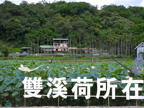
On a summer morning, before the sun shines, go to the Shuangxi Lotus Garden to enjoy the flowers. The peach-pink lotus flowers peek out from the dense lotus leaves. Brush shoulders with children playing on the ridges beside the pond. One is looking for the best spot to enjoy the flowers, while another is looking for the crystal water drops sliding down the edges of the leaves, so the kid scoops up handfuls of water repeatedly from the pond and splashes it on the lotus fields, washing away the summer heat at the same time. After capturing all the ideal angles in the camera, there is also the farmer's market at the entrance of the garden and the handmade DIY series of lotus seasons, which are bustling with people and very lively.Then, go to the Ruanqiaoduan Water Park to play in the water and take a walk. When hungry, have a good meal at the nearby Shuangxi Old Street and stroll through the old town to feel the tranquility of the years. After a full stomach, look at the Chinese architectural aesthetics of the Lian Juren Historic House and the Zhuang Gong-Sheng Ancient House. The simple and charming inscriptions and carvings give a glimpse of the time's cultural status and social expectations.▲ About 30% of the flowers bloom in mid-June, and many lotus flowers are still in the bud. The flower season will last until August.The largest lotus field in New Taipei City is where to seize the limited beauty in summer.While driving on the Shuanggan Highway, flower fields are on both sides. The largest lotus garden field in New Taipei City is in Shuangxi. Shuangxi Lotus Garden has promoted friendly farming for more than ten years, with a scale of 7.5 hectares. Besides the two significant representatives of water lily fields, lotus, and water lily, the garden also planted various varieties such as Oga lotus, peony lotus, perfume lotus, Victoria regia, and louver lotus. The limited seasonal beauty kicked off in June and continued to bloom until August. ▲ DIY coin purse of silk printing involves smearing the pigment on the silk board and scraping the pigment evenly from top to bottom with a scraper.The "Shuangxi Lotus Season" officially opens in mid-June. The pond is full of flower buds, making people look forward to the scene of full bloom in midsummer. The organizer has prepared a series of handmade DIY activities to match the flower season, from making palace-style lotus pastry and experiencing silk printing of coin purses to creating lotus-shaped light soil pots. Many parents accompanied their children to participate. Walking along the farmer's market corridor with their finished works, they can't help but hold tofu pudding in one hand and honey water in the other, trying their best to resist the arrival of the hot summer. Organic fruits and vegetables, eggs, and pickled vegetables from local small farmers filled the stalls. In the hustle and bustle of chatting and selling goods, experience the gentleness and kindness of the Shuangxi people in such a leisurely life.▲ The entrance to the Ruanqiaoduan Water Park is on the side of the road. We recommend parking cars and then walking here.The clear and transparent secret water play spot relieves summer heat.Using ecological methods to build the Ruanqiaoduan Water Park, its entrance is next to the Pinglin section of the Jifu Highway. Walk down the stone steps, the view suddenly opens, and the green lawn appears. At the end of the lawn are stairs for easy entry into the water. The closure of Pinglin River banned fishing successfully, so now the water is clear, and you can see the bottom. There are also schools where fish can swim leisurely, including Taiwan shoveljaw carp and Taiwan torrent carp. This place has become a good place for the whole family to play in the water and have picnics.When playing in the water, be aware of the impact of chemical sunscreen on the aquatic environment, as it may cause ecological accumulation and even affect the endocrine system of marine organisms. When contacting natural waters in the hot summer, choose ocean-friendly sunscreen, or enjoy the sun!▲ At the end of the lawn are stone steps leading to the stream. The stream is shallow, and many fish swim leisurely in it.Stroll through the tranquil Shuangxi Old Street to explore the ruins and enjoy delicious food.After playing in the water and feeling hungry, why not go to the nearby Shuangxi Old Street to search for food? Unlike the noise of Shenkeng Old Street and Pingxi Old Street, the atmosphere of Shuangxi Old Street adds a sense of peaceful life to the old city area. Strolling through it, run against a century-old blacksmith shop made of red bricks at the corner and a two-story Western-style building Chinese medicine shop with the sign "Lin-Yi-He Pharmacy" hanging on it. Looking at the exterior of the building, it seemed like time had passed, but only by delving into it did you realize that everything was still steadily rotating.▲ The century-old blacksmith shop has witnessed Taiwan's development history from an agricultural society.Shuangxi Public Market gathers many people, and hidden delicacies are all around, whether it is the Caozaiguo with a chewy skin and a grassy aroma, filled with shredded radish, or the traditional shaved ice with dozens of ingredients to choose from. Although it lacks exquisite decoration, the market's delicious food still has a down-to-earth charm that makes residents and tourists visit repeatedly.▲ At the end of Changan Old Street is Shuangxi Old Ferry Dock, where the Pinglin and Mudan rivers also meet.At the end of Changan Old Street is the remains of Shuangxi Ferry Deck, which was the traffic hub of the Tamsui-Kavalan Historical and Cultural Trails during the Qing Dynasty, creating a prosperous period for Shuangxi Town. Changan Street was full of rice shops, cloth shops, inns, and Chinese medicine shops during its heyday.▲The words "Chuzhong (transferring filial piety towards parents)" and "Riuxiao (to show loyalty to the country)" are engraved on the left and right doors of the "Lian Juren Historic House."The ancient house tour is to explore the Shuangxi from a century-old mansion.There is also a century-old house called "Lian Juren Historic House" near the ferry dock. A large plaque with the words "Wenkui" is hung on the main hall door. In the past, people would thank their ancestors after achieving fame. At this time, local officials would present plaques to show their appreciation. Hanging plaques can also show the family's status in the imperial examination. In the fifth year of the Tongzhi reign of the Qing Dynasty (1866 AD), Yuan-Qiao Lian's descendant, Ri-Chun Lian, went to Fuzhou to take the provincial examination and passed the Bingzi imperial examination. He was the first imperial examination in Shuangxi District, so his house was honored as "Juren House." This "Wenkui" plaque was erected by Ri-Chang Ding, Fujian's governor, in 1876 AD.▲ The walls of the “Zhuang Gong-Sheng Ancient House” contain many meaningful stone carvings, which show the blessings and expectations of the ancestors.In the 34th of the Meiji era (1901), Ting-Can Zhuang went to Zhangzhou Prefecture in Fujian Province to participate in the Qing Dynasty's imperial examination and passed the imperial examination. After returning home, he co-founded the "Mei Zhu Yuan" private school with local Juren, Ri-Chun Lian, to cultivate talents. The locals called Ting-Can Zhuang's ancestral home the "Zhuang Gong-Sheng Ancient House." Mountains back the Zhuang's ancient house and face water in three courtyards in Fujian style architecture. It has circular stone windows with bamboo window frames on both sides and bats surrounding them, full of blessings, noble character, and unquestionable integrity.▲ The stone windows of the "Zhuang Gong-Sheng Ancient House," with bamboo window frames and bats surrounding them, are full of blessings, noble character, and unquestionable integrity.These century-old houses are still in their original stone appearance and are generally well preserved. Visitors can still see the intricate carvings under the traces of time. Through explanations from later generations, people can get a glimpse of Shuangxi's prosperous past. Time has preserved the stories of the old streets and houses waiting for visitors to explore one by one on foot.