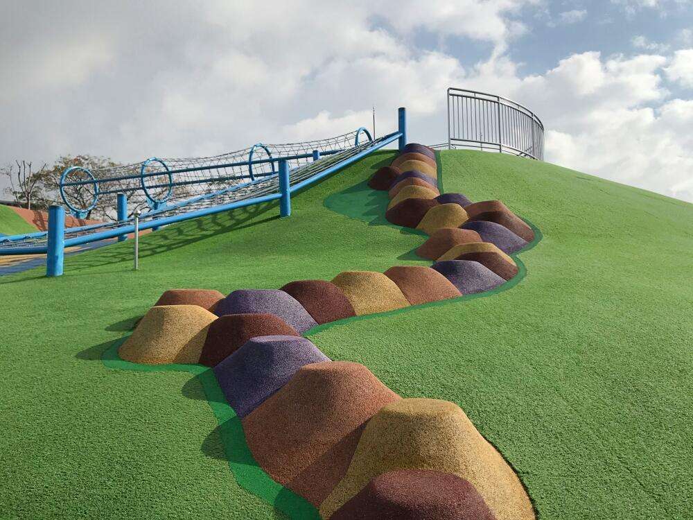
Go to the main content section Anchor point

New Taipei City Travel

Walk through the ancient corridors of Zhonghe, and scale the mountain to pray for good fortune

Anchor point
Walk through Zhonghe
Category :
Senior citizen & Outdoor excursion
Travel days :
1 day
適合對象 :
Public & The aged

推薦路線

Day

      Introduction

      Anchor point
      Compared to the Xinzhuang and Wanhua districts, the Zhonghe district is considered an area which was developed much later; however, each area has its own past and its own story. If you slow down, you will realize that Zhonghe’s historical sites are very close to our lives. Visit traces of history hidden in the parks, discover the past and present of Zhonghe district, and then visit the temples toward the mountains to pray for future peace.

      Located in Zijiang Park, the Mizuho Pond is a municipal monument with a rectangular-shaped main building which is supported by Tuscan columns. Completed in 1929, it is part of the Banqiao waterway system, connecting the development of the Banqiao and Shuanghe areas, and greatly improving the water quality in the Banqiao area, making it an important historical landmark in the modernization of Taiwan’s sewage systems.
      瑞穗配水池

      The Yuanshan Park, which was expanded in 2018, has a long slide, a grass skating field, a zip line, and various other facilities, making it a great place for families to visit. On top of that, there is also a municipal monument: The remnants of the Haishan Shrine. This shrine was built in 1938, when the Japanification policy was implemented in Taiwan. At present, there are remains of stone walls, stone stairs, torii gates, and air-raid shelters at the Haishan Shrine, which are worth exploring when visiting the park.
      員山公園

      The Yuantong Temple was built in 1927, and is an architectural mix of traditional Taiwanese, Japanese and Western styles. It is one of the famous temples of the Caodong school in the north of Taiwan, which was featured in the classic movies “Brother Liu and Brother Wang on the Roads in Taiwan” and “The Heaven Sword and Dragon Saber.” Behind the temple are several hiking trails connecting various different hiking routes in the Zhonghe area.。
      圓通禪寺

      Huaxin Street is the most diverse street in Taiwan when it comes to Southern cuisine; it is home to many descendants of soldiers and residents who moved from Yunnan to Myanmar and Thailand for retirement, so almost all restaurants on Huaxin Street offer Burmese, Yunnan and Thai food, such as shredded baba, coconut chicken, noodles in fish soup, curry chicken, spicy pho, shredded chicken noodles, and pea fritters. Many signboards are even written in Burmese, and the staff of these restaurants speak it as well!
      緬甸街緬甸文招牌

      Xingnan Road crosses National Highway No.3 with two side roads, one leading to the White Horse Temple, which is dedicated to Shakyamuni. The name of the White Horse Temple is derived from the first temple built after Buddhism was introduced in China, the White Horse Temple in Luoyang, which is a temple practicing Pure Land Buddhism.
      白馬寺

      The other road, which goes uphill, leads to the Hongludi Nanshan Fude Temple. This local temple, which is more crowded at night than during the day, is without a doubt the most popular temple of the God of Wealth in northern Taiwan. From the temple, you can look down at the million-dollar night view, and plan out your future self!
      位於正殿的福德正神像
      day01
        Previous
        One-Day Railway Trip on the Pingxi Line
        As the train enters Yilan Line from Ruifang, we will arrive at Houtong and enter Pingxi Line from Sandiaoling. This railway line stretches amidst the verdant and lush mountainous area of Northern Taiwan, was built due to past prosperous coal mining industry, and is still operating. Besides transporting passengers, this is a popular route for railway trips in which it starts from Houtong. The magnificent achievements of the mining industry can be seen throughout the place in which they brought about railways and the prosperous development of towns along the way. Coming to Shifen, the origin of Sky Lantern and the largest station along the Pingxi Line, this is a major train intersection station. Looking back at the mining history of Pingxi, Shifen is the earliest and largest settlement developed. Its greatest feature is that the old street stands side-to-side with the railway track and presents the unique railway scenery of “the train passes through your front door”. Although the coal mining industry is a thing of the past, countless coal mining relics still remain along the Pingxi Line. It is rich with scenery and culture, in which visitors can seek tranquility at small unmanned stations, or enjoy traditional gourmet foods, visit grocery stores and hardware stores dating back to your grandparents’ days at bustling old streets. You can also get a Happiness Stamp at the station or fly a Sky Lantern written with your wishes for this year. You can enjoy a spectacular day and this is the branch line you cannot dare to miss.
        Next
        Tarcking back the refreshing Daluolan River in the Ataya tribe of Wulai
        Wulai stands as the most expansive and highest-altitude region within New Taipei City. It represents the sole mountain indigenous district in New Taipei City, primarily inhabited by the Atayal ethnic group. The name "Wulai" originates from the Atayal word "Ulay", signifying the presence of hot springs. Upon entering the North 107 Rural Highway from Wulai Scenic Bridge, you will encounter the idyllic Tranan Tribe, akin to a hidden paradise. Visitors can leisurely walk along the lifeline of the tribe, the Daluolan (Tranan) River, roll up their pants, and immerse themselves in the refreshing river waters to escape the summer heat.Located about a half-hour drive from Wulai Old Street, Tranan Tribe is the first settlement of the Atayal people migrating from Balong in Taoyuan to Wulai in New Taipei City. Situated within the Nanshi River Watershed Protection Area, this small yet beautiful tribe has deliberately avoided excessive development, allowing inhabitants of this region to preserve the most traditional Atayal lifestyle in Wulai. Within the tribe, one can observe characteristic wall paintings and sculptures portraying themes centered around Atayal culture and beliefs.The Daluolan River, known as the mother river of the Tranan Tribe, derives its name from the Atayal word “Tranan” and serves as one of the tributaries of the Nanshi River. A century ago, Atayal people from Balong crossed over the mountain range in search of hunting grounds. They discovered this area, abundant in water sources and fertile soil, and gradually relocated here. During the Japanese domination period, the authorities at the time constructed irrigation canals to channel the waters of the Daluolan River to the tribe for farming purposes. The valley of the Daluolan River is lush and verdant, with the river channel varying between narrow passages and wide expanses. With groups of Taiwan shovel-jaw carps (Onychostoma barbatulum) swimming in crystal-clear waters, it has an astonishingly picturesque scenery.Both banks of the Daluolan River are equipped with scenic trails. The northern bank features an ancient canal trail, while the southern bank hosts the recently established Xilong Trail. The ancient canal trail, also known as the "Fushan Maan Ancient Canal Trail", no longer serves its original irrigation function but continues to flow endlessly. Surrounded by the shade of lush trees, the trail is adorned with towering old trees on both sides and various ferns thriving along the way. The trail is also furnished with rest areas and the Butterfly Garden, offering visitors a beautiful view of butterflies fluttering during the summer.The Tranan Scenic Bridge stands out as the newest attraction in the tribe, connecting the Ancient Canal Trail and Xilong Trail to form a circular route. This steel-structured arched bridge gracefully spans over the Daluolan River. As visitors traverse its path, they're greeted by breathtaking views of the valley and distant mountain peaks. The harmonious fusion of the river and lush forests crafts an invigorating visual spectacle. Returning to the tribe via the Xilong Trail, travelers encounter two intersecting paths that lead to the Daluolan River. Here, guests have the chance to kick off their shoes, roll up their pants, and immerse themselves in the refreshing waters, offering sweet respite from the summer's warmth.While returning to Wulai Old Street via the North 107 Rural Highway, take a moment to gaze toward the right bank where the cable car station of Yun Hsien Resort lies. Here, you can relish the captivating view of the majestic Flying Fountain gracefully descending from the mountaintop. Also known as Yunxian Waterfall, the impressive 80-meter-high cascade stands as the largest waterfall in Northern Taiwan. Since the Japanese colonial period, it has been revered as 'the waterfall from the clouds,' remaining one of the most renowned landscapes in Wulai.After crossing the Wulai Tourist Bridge, turn right to enter the most bustling area of Wulai – Wulai Old Street. Indulging in aromatic indigenous cuisine is a delightful reward after hiking. All the shops along Wulai Old Street have similar signboards. Here, you can discover various indigenous cuisines and local specialties. For instance, rice dumplings, bamboo tube rice, makauy (Litsea cubeba) dishes, bird's-nest fern, shallot, BBQ wild boar meat, hot spring eggs, millet mochi, and more. Let’s relish these local delicacies and satisfy your taste buds!
        Read more
        Back to the top of page
        小客帶路