Go to the main content section Anchor point

New Taipei City Travel

Tarcking back the refreshing Daluolan River in the Ataya tribe of Wulai

Anchor point
Category :
Hiking Trails & Family tour & Outdoor excursion & Secret attractions
Travel days :
1 day
適合對象 :
Public & Family & Couples

推薦路線

Day

Introduction

Anchor point

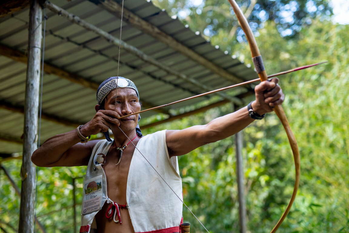
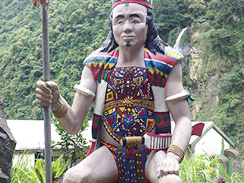
Wulai stands as the most expansive and highest-altitude region within New Taipei City. It represents the sole mountain indigenous district in New Taipei City, primarily inhabited by the Atayal ethnic group. The name "Wulai" originates from the Atayal word "Ulay", signifying the presence of hot springs. Upon entering the North 107 Rural Highway from Wulai Scenic Bridge, you will encounter the idyllic Tranan Tribe, akin to a hidden paradise. Visitors can leisurely walk along the lifeline of the tribe, the Daluolan (Tranan) River, roll up their pants, and immerse themselves in the refreshing river waters to escape the summer heat.

烏來福山

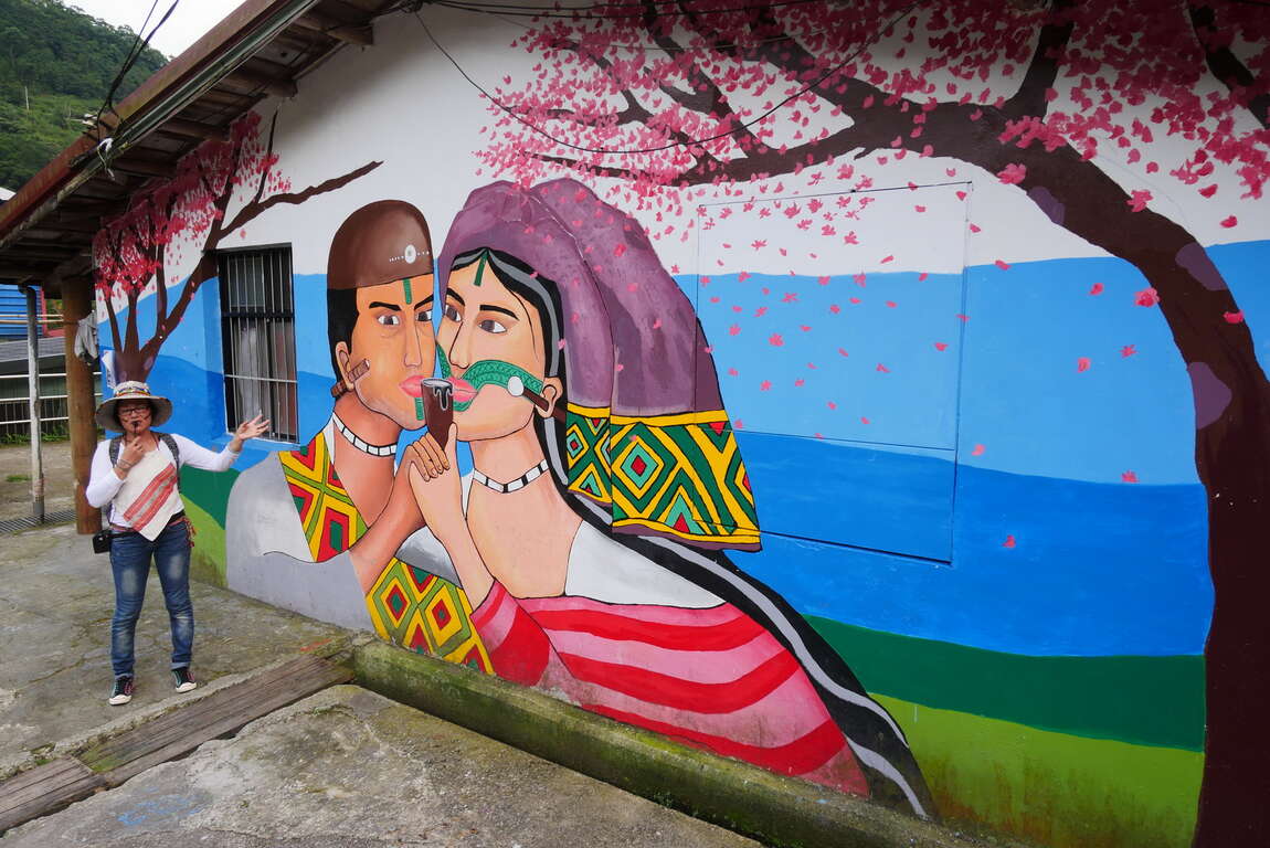
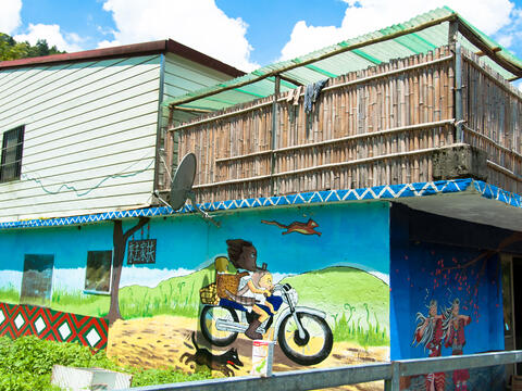
Located about a half-hour drive from Wulai Old Street, Tranan Tribe is the first settlement of the Atayal people migrating from Balong in Taoyuan to Wulai in New Taipei City. Situated within the Nanshi River Watershed Protection Area, this small yet beautiful tribe has deliberately avoided excessive development, allowing inhabitants of this region to preserve the most traditional Atayal lifestyle in Wulai. Within the tribe, one can observe characteristic wall paintings and sculptures portraying themes centered around Atayal culture and beliefs.
德拉楠部落
獵人生活體驗

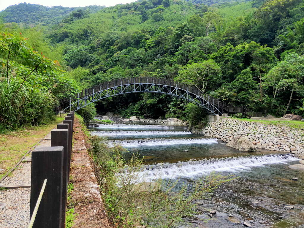
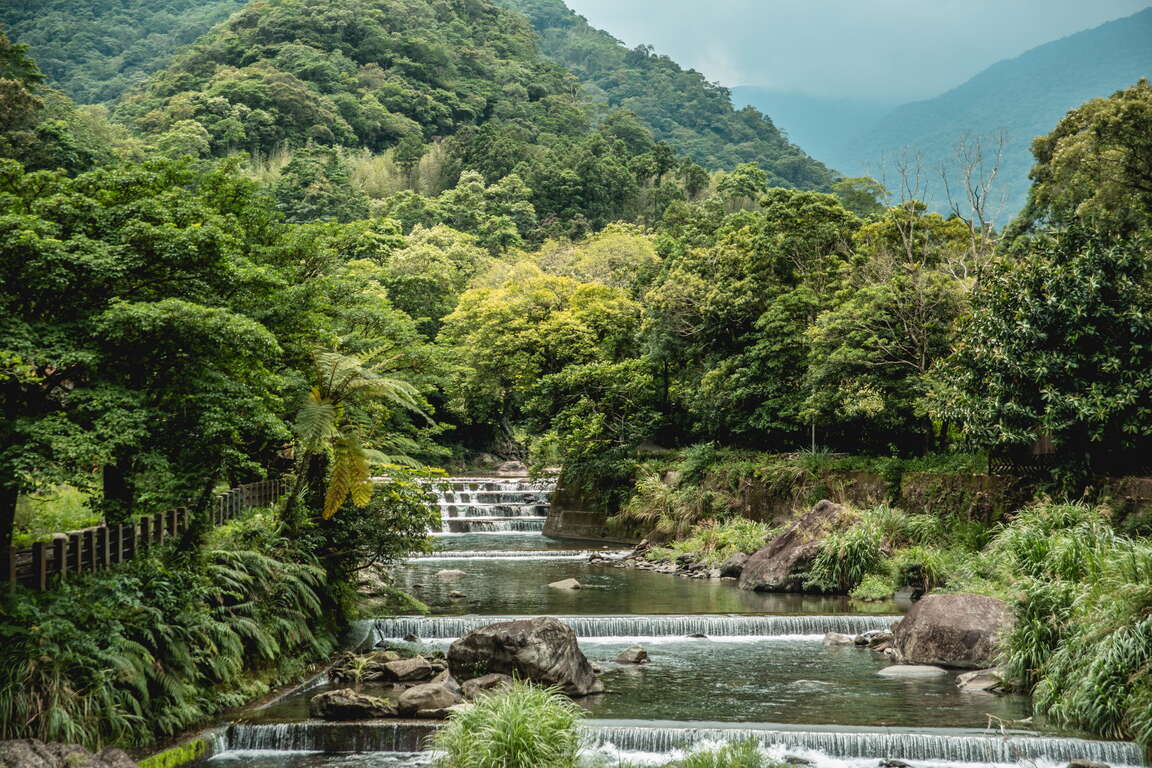
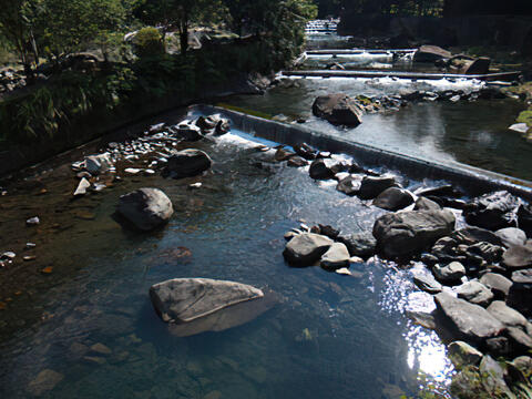
The Daluolan River, known as the mother river of the Tranan Tribe, derives its name from the Atayal word “Tranan” and serves as one of the tributaries of the Nanshi River. A century ago, Atayal people from Balong crossed over the mountain range in search of hunting grounds. They discovered this area, abundant in water sources and fertile soil, and gradually relocated here. During the Japanese domination period, the authorities at the time constructed irrigation canals to channel the waters of the Daluolan River to the tribe for farming purposes. The valley of the Daluolan River is lush and verdant, with the river channel varying between narrow passages and wide expanses. With groups of Taiwan shovel-jaw carps (Onychostoma barbatulum) swimming in crystal-clear waters, it has an astonishingly picturesque scenery.
大羅蘭溪

Both banks of the Daluolan River are equipped with scenic trails. The northern bank features an ancient canal trail, while the southern bank hosts the recently established Xilong Trail. The ancient canal trail, also known as the "Fushan Maan Ancient Canal Trail", no longer serves its original irrigation function but continues to flow endlessly. Surrounded by the shade of lush trees, the trail is adorned with towering old trees on both sides and various ferns thriving along the way. The trail is also furnished with rest areas and the Butterfly Garden, offering visitors a beautiful view of butterflies fluttering during the summer.
福巴吊橋

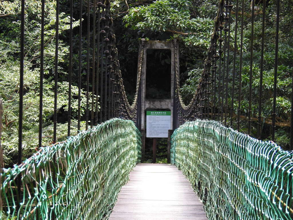
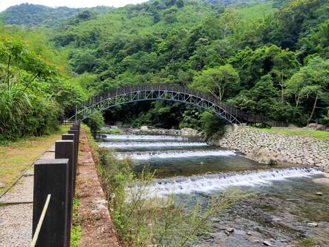
The Tranan Scenic Bridge stands out as the newest attraction in the tribe, connecting the Ancient Canal Trail and Xilong Trail to form a circular route. This steel-structured arched bridge gracefully spans over the Daluolan River. As visitors traverse its path, they're greeted by breathtaking views of the valley and distant mountain peaks. The harmonious fusion of the river and lush forests crafts an invigorating visual spectacle. Returning to the tribe via the Xilong Trail, travelers encounter two intersecting paths that lead to the Daluolan River. Here, guests have the chance to kick off their shoes, roll up their pants, and immerse themselves in the refreshing waters, offering sweet respite from the summer's warmth.
溪瀧橋

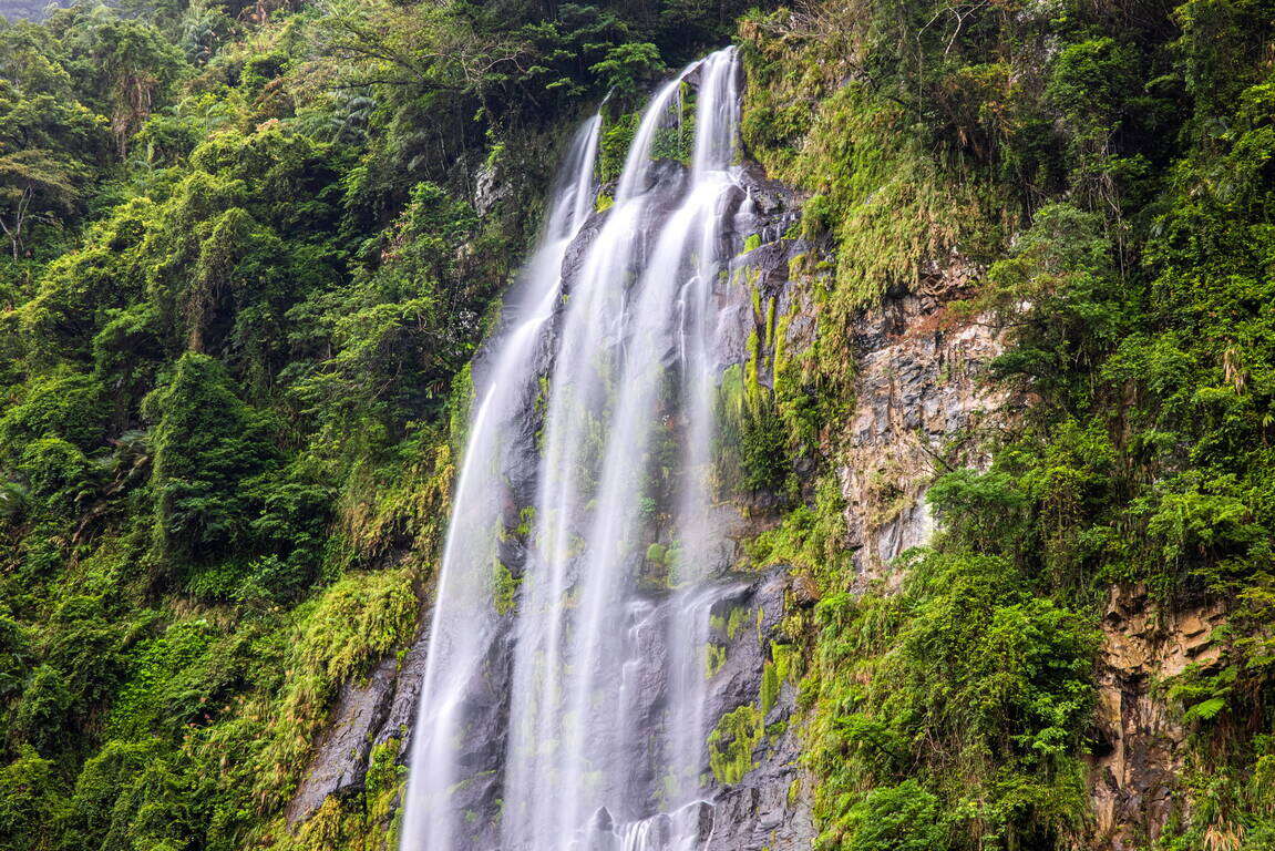
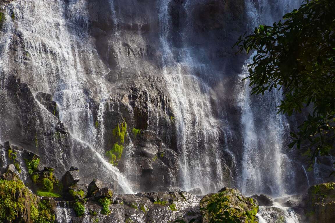
While returning to Wulai Old Street via the North 107 Rural Highway, take a moment to gaze toward the right bank where the cable car station of Yun Hsien Resort lies. Here, you can relish the captivating view of the majestic Flying Fountain gracefully descending from the mountaintop. Also known as Yunxian Waterfall, the impressive 80-meter-high cascade stands as the largest waterfall in Northern Taiwan. Since the Japanese colonial period, it has been revered as 'the waterfall from the clouds,' remaining one of the most renowned landscapes in Wulai.
烏來瀑布
烏來瀑布

After crossing the Wulai Tourist Bridge, turn right to enter the most bustling area of Wulai – Wulai Old Street. Indulging in aromatic indigenous cuisine is a delightful reward after hiking. All the shops along Wulai Old Street have similar signboards. Here, you can discover various indigenous cuisines and local specialties. For instance, rice dumplings, bamboo tube rice, makauy (Litsea cubeba) dishes, bird's-nest fern, shallot, BBQ wild boar meat, hot spring eggs, millet mochi, and more. Let’s relish these local delicacies and satisfy your taste buds!
烏來老街
烏來老街
Previous
Exploring New Taipei by Taipei MRT – Zhonghe-Xinlu Line (Nanshijiao)
"There is Yonghe Road in Yonghe, and Zhonghe Road in Zhonghe. Zhonghe Road in Zhonghe connects with Zhonghe Road in Yonghe. Yonghe Road in Yonghe does not connect with Yonghe Road in Zhonghe. Zhonghe Road in Yonghe connects with Yonghe Road in Yonghe…." The "Song of Zhong-Yong-He" fully reflects the maze-like urban landscape of Shuanghe (double-he, Zhonghe and Yonghe) Area, which is the most densely populated area in Taiwan. Among them, Yonghe District has a population density of more than 30,000 people per square kilometer, which means that its mere 5.7 square kilometers of land is home to over 210,000 people! During Taiwan's urbanization period, a large number of people came to Shuanghe area, including not only Taiwanese from central and southern Taiwan looking for work, but also expatriates from Southeast Asia and South Korea. A diverse ethnic culture is therefore formed here, which also brought delicious exotic cuisine.The Nanshijiao side of Zhonghe-Xinlu Line serving Zhonghe and Yonghe Districts was the earliest to begin service on Zhonghe-Xinlu Line on Christmas Eve of 1998. There are a total of 4 underground stations, namely Nanshijiao (O01), Jingan (O02), Yongan Market (O03), Dingxi (O04). Let's take the MRT to explore Shuanghe!Nanshijiao (O01): Huaxin Street (Myanmar Street)The first stop is Nanshijiao Station, which is the main residential area of Chinese Burmese in Taiwan, including Kuomingtang troops and their families in Burma who retreated to Taiwan in the 1950s, and Chinese Burmese who were deprived of their political and economic status after the Myanmar military government came to power in 1962 and immigrated to Taiwan. They are mainly concentrated in Huaxin Street, which is also known as Myanmar Street or Nanyang Food Street. The street signs are written in both Chinese and Burmese, and the restaurant owners and employees would speak Burmese between them. It is the largest Southeast Asian community in New Taipei City. Taiwan's first Southeast Asia themed bookstore, Brilliant Time, is located here. The annual Songkran Festival is also held here!The delicacies on Huaxin Street are mainly Burmese, Indian, Chinese Yunnan, and Thai, including fish soup noodles, naans, rice noodles, pea gravy, and various milk teas! The restaurants here are homey and down-to-earth. They are typically open from morning to afternoon, offering authentic and affordable food. Huaxin Street is a treasure trove of flavors in New Taipei City.Yongan Market (O03): 823 Memorial Park (Zhonghe Park), National Taiwan LibraryNext to Yongan Market Station, you will find 823 Memorial Park, known as the "lungs of Shuanghe." Initially, six large parks were planned for the Shuanghe area. Due to the rapid inflow of people, in the end, only two parks, namely 823 Memorial Park and Renai Park, were completed. 823 Memorial Park covers an area of 11 hectares, and it is the largest park in the Shuanghe area. The August 23 Artillery Battle monument is the landmark in the park, commemorating the war that broke out in Kinmen in 1958.National Taiwan Library in the park was formerly known as the Government-General of Taiwan Library. It was the first modern library in Taiwanese history, and the No. 1 library during the Japanese Rule period in terms of size! In the 1940s, it already had a collection of more than 200,000 books. The neo-classical arched corridor on the outside of the building is a popular photo spot.Dingxi (O04): Yang Sanlang Art Museum, Zhongxing Street (Korea Street), Lehua Night MarketThe area around Dingxi Station is the busiest area in Zhonghe and Yonghe. As it is only a bridge away from Taipei City, lots of people who work in Boai Special Zone and around Taipei Station live here. Yonghe is best known for soymilk. The world-renowned Yonghe Soymilk shop originated from Zhongzheng Bridge. With its fragrant soymilk and hearty Chinese breakfast, it is a must for foodies who like northern Chinese food.Yang Sanlang Art Museum, hidden in the alley behind the soymilk shop, is the former residence of Yonghe-born oil painting master, Yang Sanlang. At the museum, Yang's representative works from each period are on display. Yang has studied in Japan and France and has been dedicated to the development of local art in Taiwan. Jointly with artists of the same era, Chen Chengbo, Liao Jichun, Yan Shuilong, and Li Meishu, Yang founded Taiyang Art Association. The wooden house on the premise is Wangxi Villa, the residence and art studio of Yang Sanlang. It is quiet and elegant. Painting tools and various items used by the master have been preserved such that we could peek into the master's dedication to art."어서오세요!" Zhongxing Street that is next to Exit 1 of Dingxi Station is also known as Korea Street. It was where many Chinese Korean coming from Shandong stayed in Taiwan. As Korean pop culture became popular all over the world, Korean goods are in high demand. Yonghe Korea Street therefore becomes a great shopping place for fans of Korean culture. There are many exclusive Korean goods, including clothing, instant noodles, kimchi, sauces, snacks, and soju. The wide variety of products is waiting for you to explore.It's dinner time! Shuanghe's kitchen, Lehua Night Market, is one of New Taipei's largest night markets. There are many well-known delicacies, offering diverse options. You can find the Taiwanese street must-haves, "fried chicken cutlet in the right hand and bubble tea in the left hand;" classic dishes such as beef soup, sesame oil chicken soup, pig blood soup, chicken rice, spicy duck blood, green onion pancake, sweet potato balls; exotic dishes such as ramen, green papaya salad, Italian coffee, and curry rice. There are so many options to satisfy all types of foodies!Some say that there is a second stomach for desserts. After a full meal, you must have some iced desserts to satisfy all senses! There are several famous ice shops in Lehua Night Market. You can choose from shaved sugar cane ice with taro, snowflake ice, and iced bean paste to draw a "cool" ending to your Shuanghe MRT tour!
Next
Visiting Qitang Old Street
In 1889, Taiwan's first railway was under construction at full speed between Keelung and Taipei. Railway construction workers discovered glittering gold dust in the river in today's Qidu area of Keelung. Those who are seeking wealth traced the river upstream, and eventually found the outcrop of gold vein in Xiaojingua and Dajingua, which kickstarted the gold mining era of Northern Taiwan. The previously quiet Jinguashi and Jiufen therefore entered their golden years. Until 1987, Taiwan Metal Mining Corporation closed the mining business and drew an end to Jinguashi's hundred-year mining history.Different from the strong commercial vibes of Jiufen, after the mining activities ended, Jinguashi became an isolated and quiet little mountain town. The buildings scattered among the emerald hills, the huge Guangong statue guarding the area, and the occasionally seen hikers in the alleys represent the present life of Jinguashi."Let us never forget." During World War II, Jinguashi was once used as a Japanese war prisoner camp. The locals called it "Dubiziliao," which meant the place where foreign prisoners were held. These prisoners of war in Southeast Asia were from Britain, the US, Canada, New Zealand, Australia, South Africa, and the Netherlands. During their imprisonment, they mined copper here under poor living conditions. Most of them did not survive the war and died in Jinguashi. In 1997, Taiwan POW Memorial and Peace Park opened to commemorate the war. "Freedom is not free" reminds the world that peace and prosperity are not easy to come by.Qitang Old Street is an important street of Jinguashi. The old street built along the mountain is the main living circle of the miners in the early years. In its most prosperous period, 80,000 gold diggers gathered here! In addition to restaurants and grocery stores, there were entertainment venues such as jewelry shops, pool halls, and bars! During the Japanese Rule period, it was known as the "Jinguashi Ginza." After the gold mining era ended, the number of residents in Jinguashi plummeted to less than 2,000. Today, the once-bustling Qitang Old Street retains a strong nostalgic atmosphere. The renovated rainbow stairs have become a topic in social media, drawing the world's attention to this mining town in the mountains again.Follow the rainbow stairs up to Jinguashi Quanji Temple, also known as Qitang (Qi Hall). The temple has been built for more than 120 years. It is the belief center of Jinguashi, dedicated to worshiping the Holy Emperor Lord Guan. The most treasured object at Quanji Temple is the largest Guan Gong statue in Taiwan that is made of pure copper and 10.6 meters in height. This statue of Guan Gong reading Chunqiu (the Spring and Autumn Annals) and standing majestically at the high point of Jinguashi against the mountains and facing the sea is the most visible landmark of Jinguashi. It is also the patron saint, blessing generations of Jinguashi people.The 260-meter-high Baoshi Mountain is named after the timed horns here during the Japanese Rule period. From the parking lot of Quanji Temple, you can walk up along the hiking trail and reach the viewing platform in 10 minutes. Facing the sea, Yin-Yang Sea and the North Coast are all within your sight. Looking back at the mountains, you can see Teapot Mountain and Liukeng Slope Cableway right in front of your eyes, surrounded by greenery and between mountains and the sea.Teapot Mountain is the backbone of the Jinguashi area, with an elevation of 602 meters. When viewed from the Jinguashi side, the ore rock at the top of the mountain looks like a teapot without a handle, earning it the cute and memorable name of "earless teapot." Teapot Mountain Trail is the most popular hiking trail in Jinguashi. It takes about 30-50 minutes to reach the top of the mountain from the parking lot of Quanji Temple. It is the most beautiful view in Ruifang. With Keelung Mountain right in front of your eyes, the little town of Jinguashi, the winding roads under your feet, and the boundless blue sky and sea, this spectacular scenery can heal you from your stressful daily life."Asia's No. 1 precious metal mine" was the prestige Jinguashi enjoyed in the past. The settlements formed around gold and copper mines in the old days carried the dreams of countless gold diggers. After the demise of the mining industry, what remained unchanged is the beautiful scenery of mountains and seas. They remain the spiritual home of hikers and Jinguashi people.
Read more
Back to the top of page
小客帶路