Go to the main content section Anchor point

New Taipei City Travel

New Taipei City’s Happy Waterfront Line: Offering a number of activities that satisfy your needs at once!

Anchor point
The colorful urban life is often accompanied by tension that is hard to relax. Don't want to travel far or be in crowded places. Let's traverse the riverbank and pass through the water gate to access New Taipei City's Happy Waterfront Line, where you can relish the fresh air and scenic riverside environment! Developed along the Tamsui River, Dahan River, Xindian River, and Keelung River, New Taipei City's Happy Waterfront Line boasts well-designed cycling routes, numerous recreational parks, sports facilities, and scenic bridges. This article offers a variety of riverside activities for you, including options for family fun, discovering secret spots, romantic dates, taking selfies, as well as leisurely strolling in scenic spots. Join us in exploring the riverside to rejuvenate your body, mind, and spirit!”
淡水金色水岸

Family fun: The Bear Monkey Forest of New Taipei City Metropolitan Park, Sunshine Sports Park in Xindian, and Bitan Scenic Area.
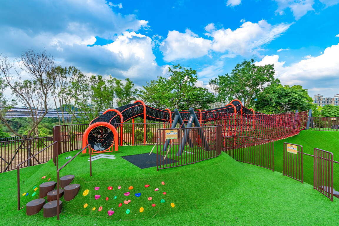
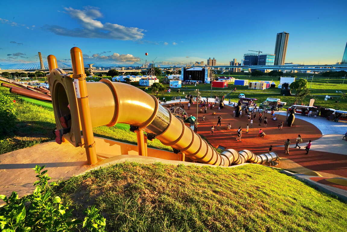
Featuring a vast expanse of over 400 hectares, the New Taipei City Metropolitan Park is a seldom-seen green corridor within the city. In recent years, both the MRT Zhonghe-Xinlu Line and the MRT Taoyuan Airport Line have established a station here (Sanchong Station), greatly enhancing the region's accessibility. The largest inclusive park in the country, “Bear Monkey Forest”, is also located within the metropolitan park. With slides inspired by the images of over 31 species endemic to Taiwan, more than a hundred recreational facilities, and an inclusive playground that seamlessly integrates with the natural terrain and ecology, Bear Monkey Forest is undoubtedly the ideal place for family fun. The “Sea World Water Park” was opened in the summer of 2022. Featuring seven aquatic facilities shaped like Taiwan's unique aquatic creatures, it has enriched the diversity of the metropolitan park!
熊猴森樂園
新北大都會公園

Sunshine Sports Park is Situated on the left bank of the Xindian River and spans approximately 20 hectares. Designed on  the theme of “Sunshine Oasis”, the park has seamlessly integrated inclusive play equipment into the existing natural hills and pebble beaches. The park is designed with six major zones: the Adventure Zone, Tree Neighbor Play Zone, Sandbox Experience Zone, Green Shade Forest Zone, Green Picnic Zone, and Butterfly-Shaped Waterway Zone.
It also features a roller-skating track, a 400-meter running track, a beach volleyball court, and a soccer field, making it one of the top sports leisure parks in Xindian.
陽光運動公園

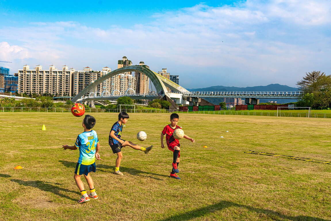
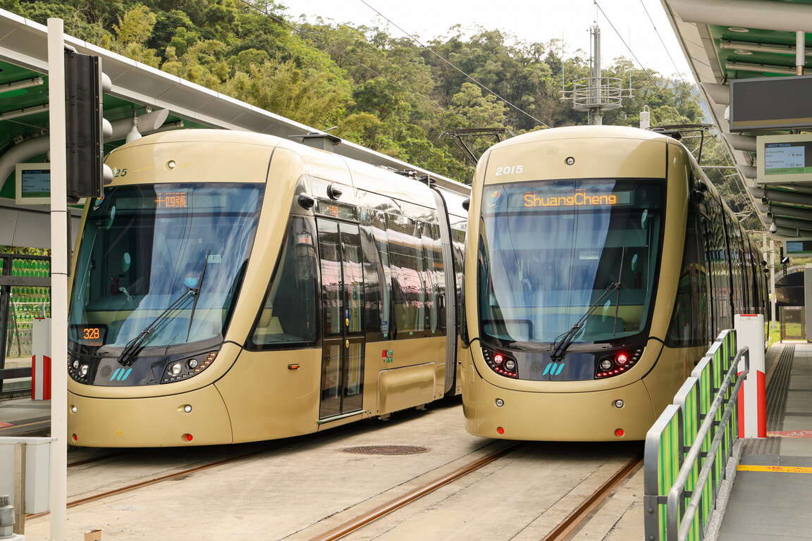
The 2023 Ankeng Light Rail, launched in February 2023, also set up the K07 Sunshine Sports Park Station here. By transferring from Shisizhang Station on the MRT Circular Line to the Ankeng Light Rail, it only takes a two-station ride to easily arrive at Sunshine Sports Park, allowing visitors to enjoy the beautiful riverside scenery upon arrival.
👉Recommended Itinerary:Following the launch of Ankeng Light Rail: A new travel tip that connects Ankeng and Xindian
安坑輕軌

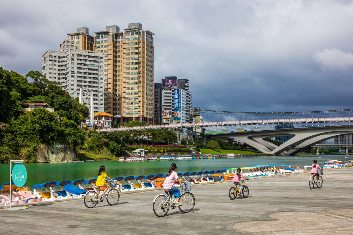
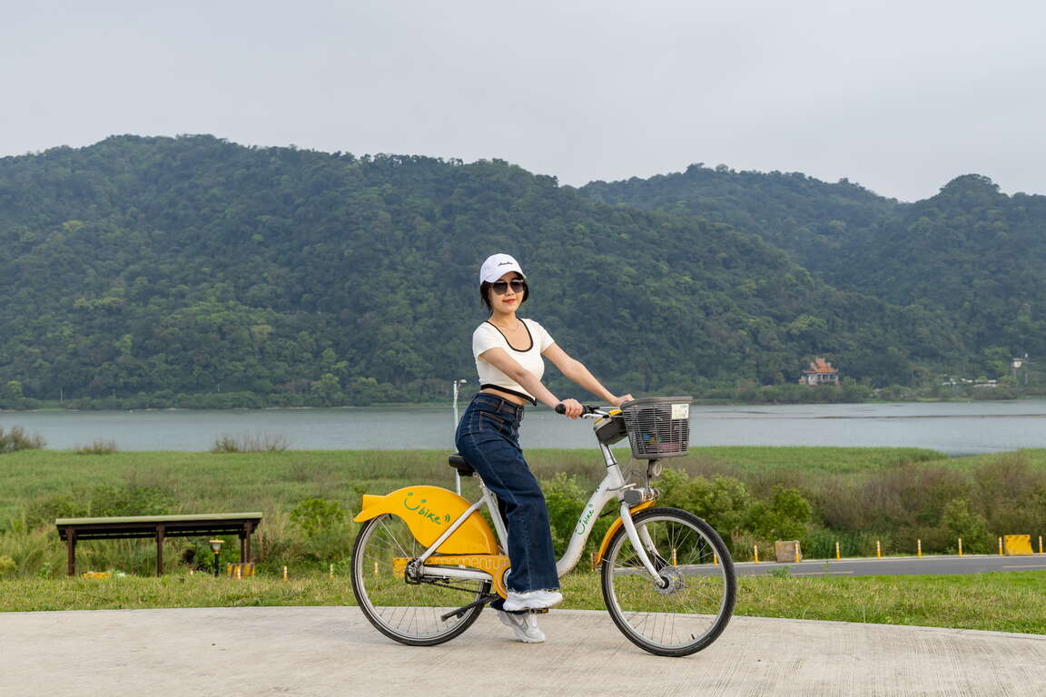
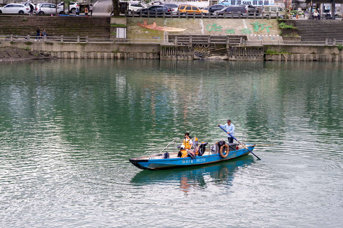
Bitan, nestled amidst picturesque mountains and a serene lake, stands as a celebrated gem of northern Taiwan, steeped in both history and natural splendor. A must-do when visiting Bitan is to embark on a tranquil boat ride across the lake. Collaborate with your family members as you paddle together on a pedal boat, fostering stronger bonds while soaking in the enchanting riverside vistas and the captivating allure of Bitan's Little Red Cliff from up close. While holding your children's hands, walk across the long-standing Bitan Suspension Bridge to enjoy a high vantage point overlooking the scenic view of the emerald lake waters and Hemeishan. Afterward, head to the East Coast Food Square to savor delicious dishes while enjoying the gentle breeze.
碧潭吊橋

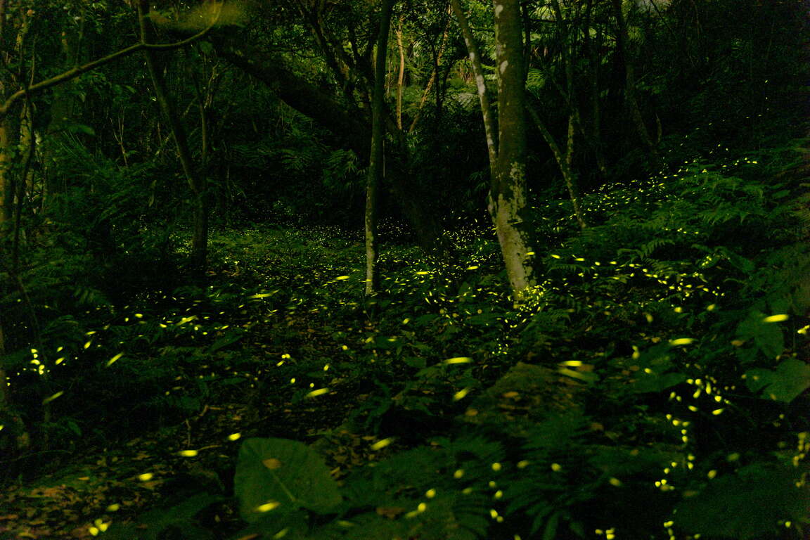
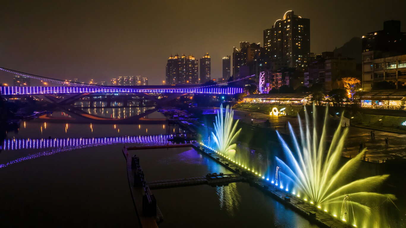
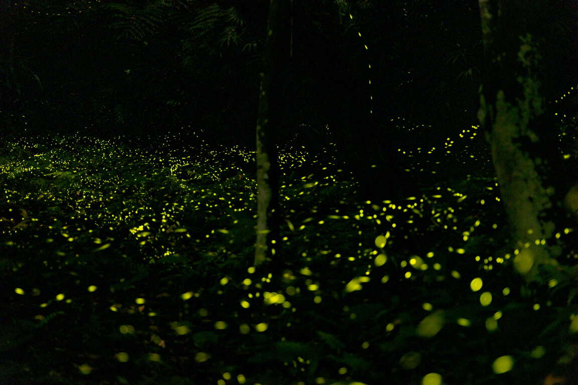
When the spring transits to summer each year, the Bitan’s water dance and Hemeishan’s fireflies make their appearance simultaneously. The magnificent water dance takes place in the center of Bitan, painting the night sky of Xindian with its vibrant display. The forest of Hemeishan, on the other hand, is full of fireflies flying around as it is the most active time for fireflies, brimming with vitality and energy.
碧潭水舞
和美山螢火蟲


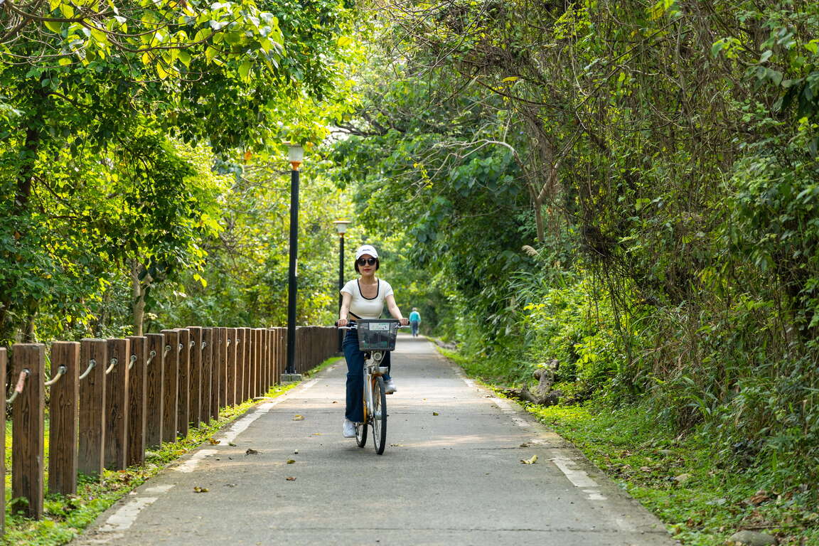
Discovering secret spots: Xizhi Wudu Cycling Route and Yingge Central River Sunset Trail
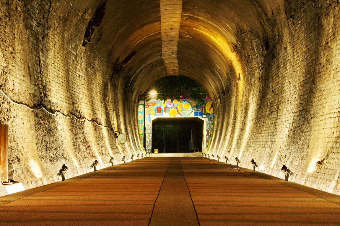
Amidst the changing lights and shadows, the arched space of the old brick tunnel felt like a time machine, transporting you back to when it was built during the Japanese era. After undergoing restoration and revival, the TRA's Old Wudu Tunnel, now equipped with lighting fixtures and a cycling route, has emerged as the most captivating stretch along the Keelung River cycling routes, once again showcasing its rich historical charm.
👉Related Articles:The Xingfu Waterfront – Exploring New Taipei by cycling

五堵自行車道

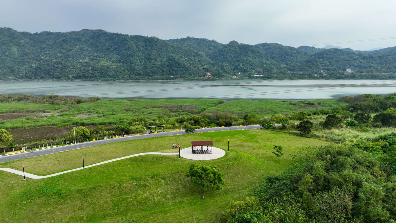
The calm and waveless river reflects the silhouette of Yuanshan (Yuan Mountain), creating a picturesque rural scene. Located at the boundary between New Taipei and Taoyuan, the Yingge Central River Sunset Trail is part of the Dahan River Cycling Route. Nestled amidst the mountain and lake views crafted by Yuanshan and Yuanshan Weir, it is a hidden gem away from the urban hustle and bustle. Let's ascend to the observation platform perched on a small hill, and savor the splendid scenery of mountains and waters in solitude.
山水步道

Romantic dates and taking selfies: Bali Left Bank and Tamsui Golden Anchor
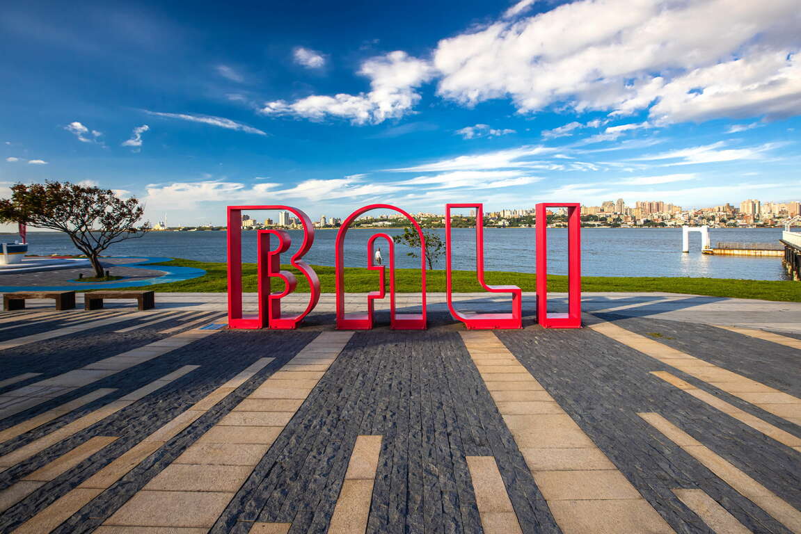
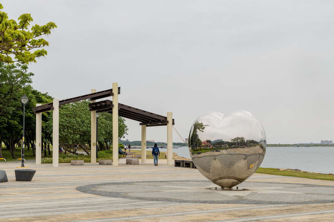
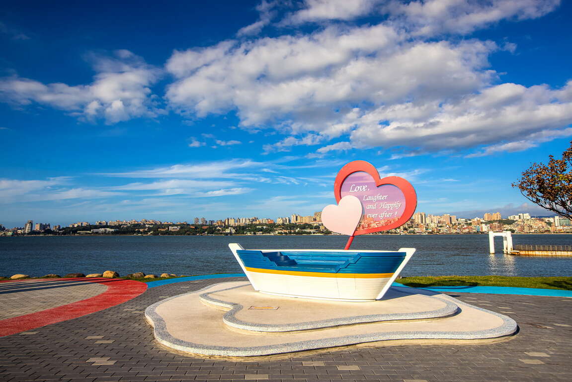
While strolling along the from the Bali ferry terminal to the Bali Left Bank Strolling Square, you will discover several beautiful photo spots. Bali Left Bank is a great place for loved ones to visit! The “Bali Landmark” that exudes exotic charm, the heart-shaped “Mirror of Happiness” sculpture, and the dreamy “European-Style Domed Pavilion” - let's capture the romantic and picturesque moments with your mobile phone! Select an outdoor café to enjoy a leisurely afternoon coffee break and savor the stunning sunset over the Tamsui River.
八里左岸的船隻造型裝置藝術
八里左岸漫步廣場

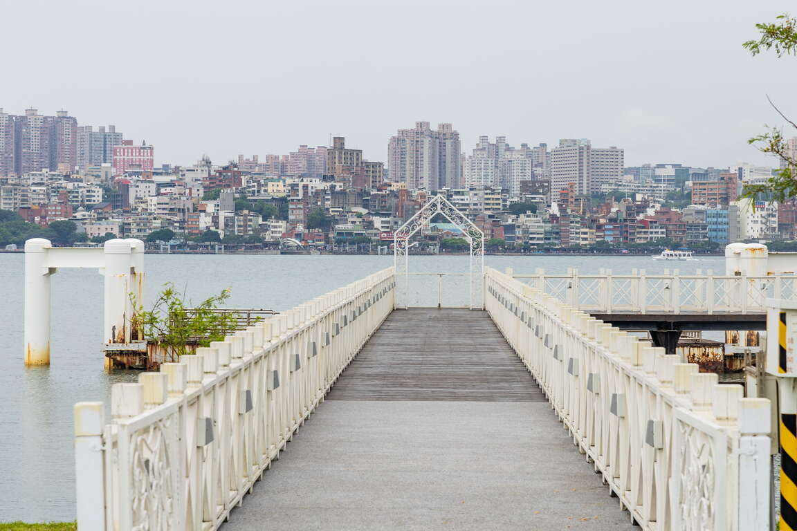
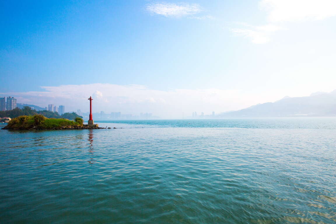
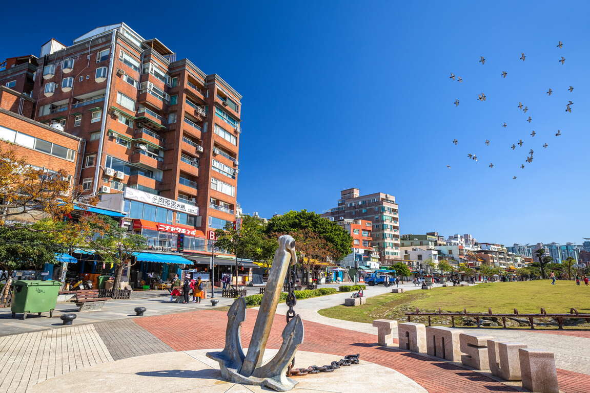
Tamsui Golden Anchor is located on the outer edge of Tamsui Old Street. It features a shaded promenade along the Tamsui River, waterfront areas, fishing spaces, a waterside stage, coffee seating, and a tidal observation bay. Strolling along the Tamsui River while gazing into the distance at Guanyinshan (Guanyin Mountain) on the opposite bank and the wide estuary of the Tamsui River brings a sense of tranquility to one's heart and mind. Along the Golden Anchor, you can leisurely explore renowned historic relics of Tamsui, such as Tamsui Customs Wharf and Fort San Domingo. These historic landmarks bear a unique blend of Eastern and Western influences in Tamsui.
金色水岸
淡水老街


Leisurely strolling in scenic spots: Xindian’s Sunshine Bridge, Xinzhuang’s Crescent Bridge, Xizhi’s Starlight Bridge, Sanchong’s Sunlight Bridge, and Yingge’s Longyao (Dragon Kiln) Bridge.
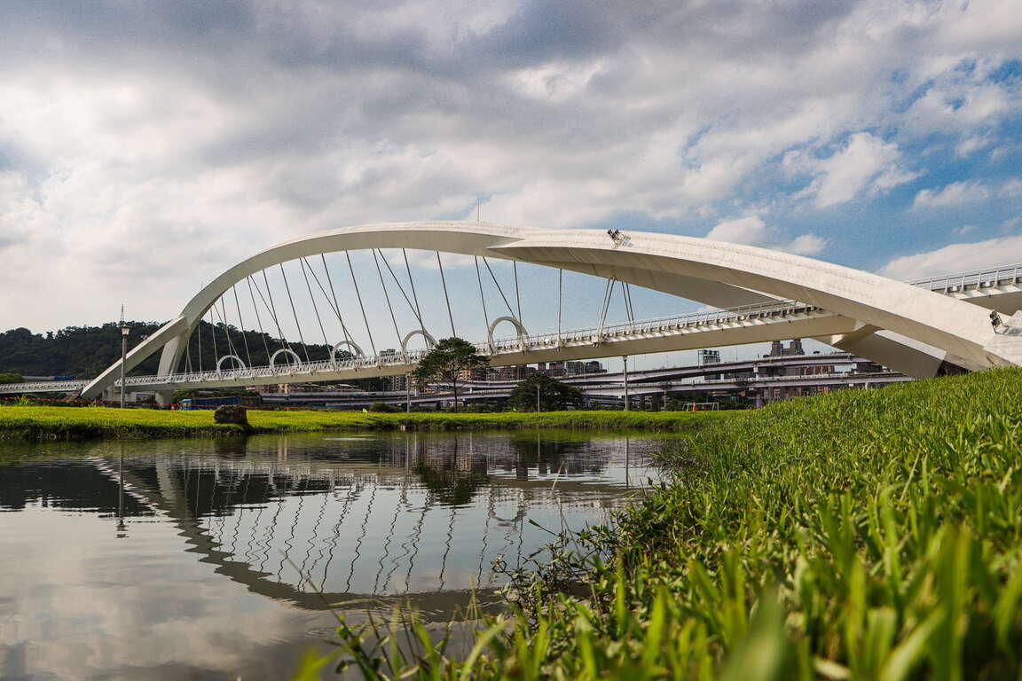
Although the Tamsui River and its tributaries have brought abundant resources to New Taipei City , they have also divided the Taipei Basin. To enhance the convenience of land transportation, New Taipei City has constructed dozens of bridges along the riverbanks. Among them, there are five beautifully designed scenic bridges specifically built for pedestrians and cyclists, collectively known as the “Sun, Moon, Stars, and Dragon”, forming the most beautiful architectural landscape along New Taipei City's Happy Waterfront Line. Each of these scenic bridges is designed with a beautiful projection mapping light show that captivates people's attention during the day and at night!

新月橋

Launched at the end of 2011, the Sunshine Bridge that connects Sunshine Sports Park with Zhongyang New Village is the first people-oriented river-crossing scenic bridge in New Taipei City. Not only is it specially designed for pedestrians and bicycles, but also it features a night projection mapping show, making it the “big brother” among  the five scenic bridges. The Sunshine Bridge is a single-rib steel arch suspension bridge that supports the bridge deck with steel cables resembling violin strings and five arches. This elegant bridge of simplicity has already become a significant landmark in the Xindian area.
新店溪陽光橋

The surface of the Dahan River reflects the double-arch bridge, creating a stunning riverside night scene with the distant crescent moon. The Crescent Bridge spans the Dahan River, connecting Banqiao 435 Art Zone with Xinzhuang Old Street. The total length of the Crescent Bridge and its approach is 1,133 m, making it the longest twin span steel arch bridge in Taiwan and the longest and most magnificent among the five scenic bridges. The Crescent Bridge has four scenic resting platforms with different features, along with the immensely popular skywalk. As you walk on the 60-meter transparent pathway, you can enjoy breathtaking views of the Dahan River below and the opportunity for a thrilling visual experience!
大漢溪新月橋月光倒影

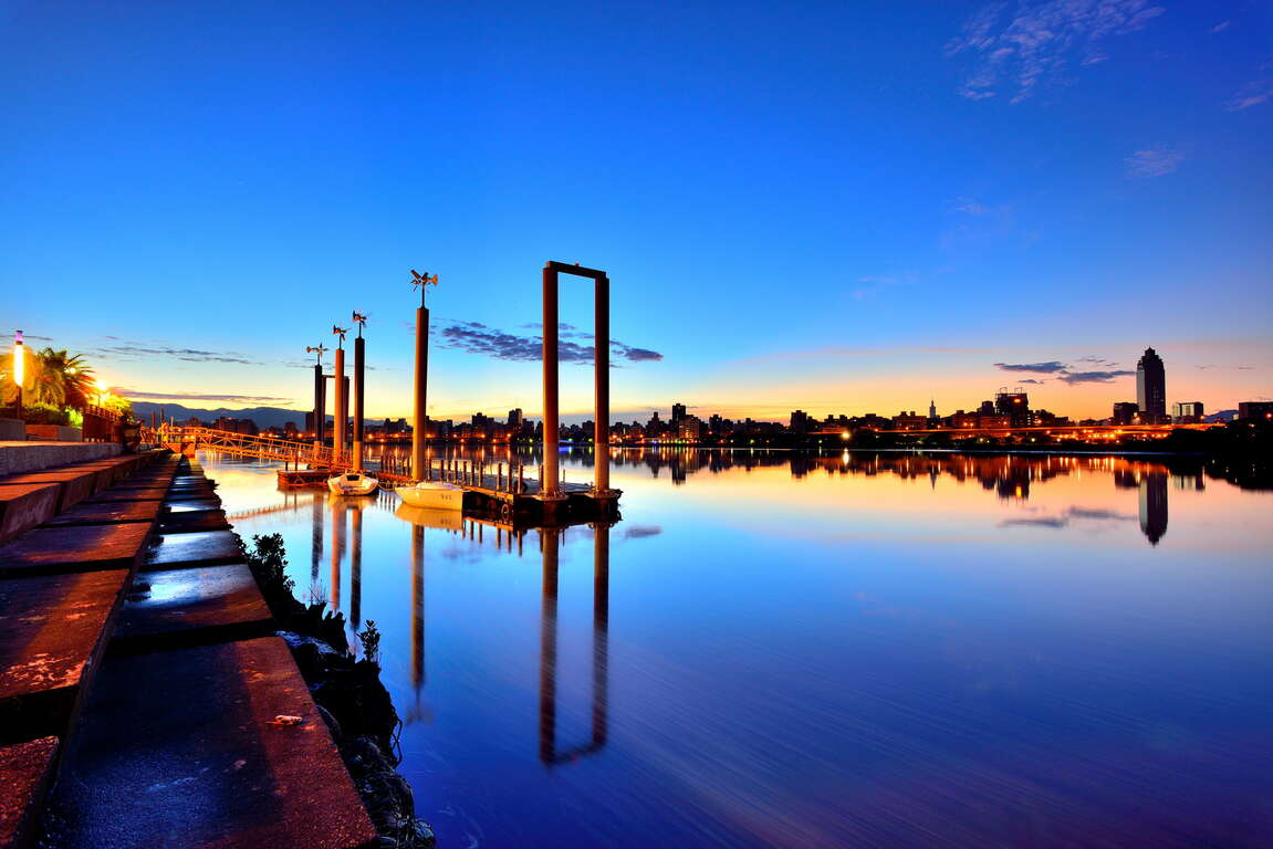
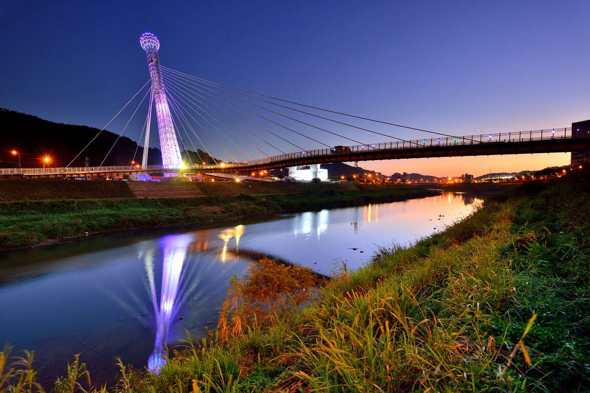
Featuring an erect giant microphone pointing towards the sky, this 270-meter Starlight Bridge in Xizhi has adopted a unique design with a “single-span cable-stay bridge” structure. Spanning the Keelung River,  the bridge is situated next to the Wudu Railway Station and its  white pillars and a bridge structure are adorned with point light sources, creating a sparkling and eye-catching starry night.
汐止星光橋

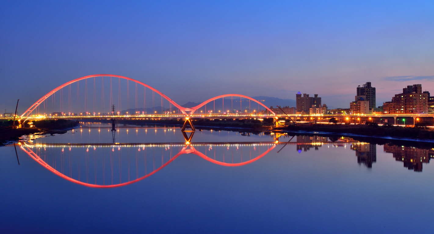
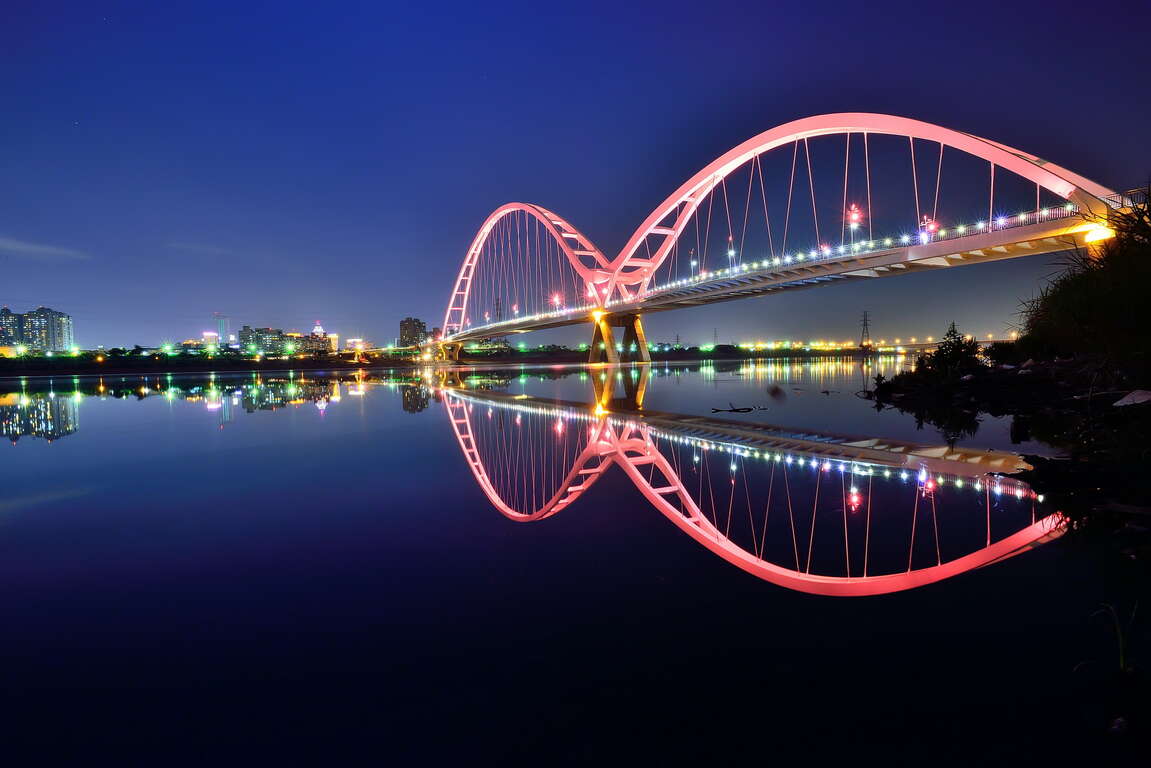
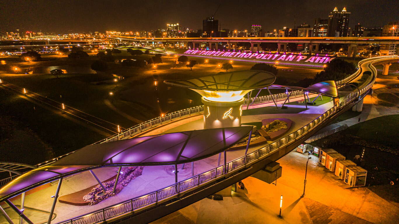
The Sunlight Bridge, located in the New Taipei City Metropolitan Park, connects the two banks of the Erchong Floodway. Its two-tier, double-curved bridge tower structure creates an observation platform; and the winding bridge deck that resembles a galaxy symbolizes the path of the Cowherd and Weaver Girl's reunion. The Sunlight Bridge is surrounded by various facilities such as a scenic stream, a water play area, a light dining and relaxation plaza, green beautification, and nighttime constellation light sculptures. These amenities enable residents to enjoy different urban landscapes, including the New Taipei City Metropolitan Park, Xinbei Bridge, and the MRT Taoyuan Airport Line, from a distance.
專為行人與單車族打造的親水景觀橋


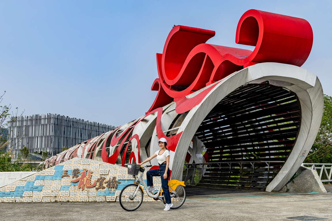
“Wind riding on clouds, dragons spewing pearls, light forming shadows, and land connecting together.” The Longyao Bridge spanning across the Yingge River is like an auspicious dragon soars above the river. The bridge, adorned with wood sculptures, represents local history, humanities, and culture. It also leads the way to the New Taipei City Art Museum, Sanying Heart Space Arts, and Yingge Ceramics Museum, allowing visitors to experience the artistic atmosphere of the Yingge village.

三鶯龍窯橋


Previous
A Journey of Taking Beautiful Photos! A Thorough Visit to the Yinhe Cave and the Hongludi Nanshan Fude Temple with a Great Night View
-->Sometimes, does having no transportation available ever stopped you from getting closer to nature on the weekends? After the operation of the Circular Line of Taipei Mass Rapid Transit Systems (Taipei MRT) begins, outing becomes easier. Would you feel like admiring the scenery or taking beautiful photos? Just follow the route, you'll find the right ways! Starting from the MRT Dapinglin Station, it's the way to a secret place called "Yinhe Cave;" people can take a stroll in the grass under tree shades for comfortable enjoyment; as soon as you hear the sound of a waterfall, people can see the extremely fascinating scene of water falling off from a cliff cave where the temple was built! Walking further to reach "Bitan" with its beautiful landscapes, people can walk across the suspension bridge to overlook the riverbank as well as try the swan-shaped paddle boats. At noon, people can take a short break at the "Pompie 2," a renowned shop that is located next to the No.4 park and recommended by the internet celebrities; quiche is the food you must try, it goes well with some desserts, such as smoothies or pieces of layer cake, people can enjoy a good lunch. If you need more food, taking a trip to "Myanmar Street" in Zhonghe can impress you so much by the strong exotic Southeast Asian atmosphere; each shop has its signature dish, the South Pacific Island cuisines are also available. The last spot to visit is the most well-known temple in northern Taiwan, "Hongludi Nanshan Fude Temple," people can thank the Earth God for his protection as well as admire the wide night view of greater Taipei before ending the wonderful one-day tour.The Yinhe Cave Hiking Trail--> Mt. Dailaokeng is the summit of the west extension belonging to the Ergeshan mountain range, it's also called Degaoling. The trail is flat and easy to hike and the landscapes along the way are lush and enticing. Dapianwei Ridge ends at Xindian River and Qingtan River, it's an easy hiking trail; along the way, there are the Yinhe Cave, Dachun Villa, etc, the lush scenes in front of the eyes are beautiful in a quiet atmosphere, a popular tourist's spot.The Yinhe Cave is right beside Beiyi Road, it's a cave having an outline that curves inwards on the cliff; there's a small temple built to worship Guanyin. The words embossed on the cliff are "Bie-you-dong-tian (means a beautiful hidden spot)." When Meiziliao River reaches here, the waterfall drops at a 90-degree angle from the cliff and forms the Yinhe Cave Waterfall. Yinhe Cave was found in the Taisho 1 (in 1912), there's a Lu Dongbin Temple built behind it. Next to the temple, there are silk-like streams of water falling from the mountain; due to water tasting sweet and refreshing, a lot of tourists come here to scoop water and drink. Under the Yinhe Cave, there's a small garden with stone tables and chairs; tourists can admire the waterfall here while enjoying the chilly atmosphere that is filled with water splashes.info.Location and Address: Yinhe Rd., Xindian Dist., New Taipei CityContact Phone Number: 886-2-29112281 (Xindian District Office)Opening Hours: All year round.Fax Number: 886-2-29670755The traffic information from the MRT Xindian Station to the Yinhe Cave Hiking Trail1. At the MRT Xindian Station, take the bus "Green Route 12" and get off at "Yinhe Cave".2. At the MRT Dapingling Station, take the Bus No. "647" or "650" and get off at "Zhongsheng Bridge".The Yinhe Cave Hiking Trail's informationBitan Scenic Area--> The “Bitan Scenic Area” is near the Taipei Metro Xindian Station. As part of the Xindian River, it is called “Bitan” (literally clear water lake) because water is clear, water flow is gentle, and the opening is spacious. In addition to the gentle slopes, beautiful mountains and the undulating bikeway suitable for lovers and family tours, the historical suspension bridge is the landmark of the scenic area.On the bridge, the entire river and shore view of the “Bitan Scenic Area” is in sight. Below, visitors can surf around the lake in a water bike (aka swan boat), rent a bike to explore the gorgeous scenery of the area along the lakeside bikeway, or stroll across the romantic and exotic “Riverside Marketplace” to take pictures with the Cupid installation art and fun 3D paintings.info.Location and Address: Xindian District, New Taipei, Taiwan 231Contact Phone Number: 886-2-29132579Opening Hours: 8:00-17:00The traffic information from the Yinhe Cave Hiking Trail to the Bitan Scenic AreaAt Yinhe Cave", take the bus "Green Route 12" and get off at the MRT Xindian Station.Bitan Scenic Area's informationPompie 2--> Located next to the No.4 Park, the owner of Pompie 2, who came back to Taiwan from Australia, hopes to introduce the authentic quiche to people, and he opened the Pompie, the previous name of Pompie 2. Afterwards, he reopened the shop with fresh flower smoothies and pieces of layer cake, and the shop's name was changed to Pompie 2. The signature flower smoothies are made of a mix of fresh fruit added with edible flowers and oats, not only healthy but also looking great in front of the camera. For sure, having the quiche for brunch is a must-eat food. The signature quiche layered by half-cooked sunny side up fried egg, pan-fried wild mushroom, salad, etc., really looking "Pompie (means abundant)"! In addition to the two kinds of food, there are pieces of layer cake, soft-serve milk ice cream, pudding, etc. available in Pompie 2. They are the best-selling desserts in summer.info.Location and Address: No.164, Anle Rd., Yonghe Dist., New Taipei CityContact Phone Number: 886-2-89418148Opening Hours: Weekdays: 1200~20:00; Holidays: 10:00~20:00; it closes on Tuesdays and from the 1st day to the 5th day of the 1st lunar month.The traffic information from the Bitan Scenic Area to the Pompie 2Take the MRT Xindian Line and get off at the Dapinglin Station; then, transfer to the Circular Line and get off at the Jingan Station. Or, transfer to the Zhonghe-Xinlu Line and get off at the Yongan Market Station. Walk through the 823 Memorial Park (No.4 Park). It takes about an 8-minute walk to reach the destination.Pompie 2's informationMyanmar Street--> Zhonghe is the home of huge immigrant population, including Burmese people who have settled down in Taiwan. A small market of Burmese food on Huaxin Street was formed after some Burmese immigrants decided to open Myanmar restaurants to satisfy their craving for the foods of their homeland. The market is now called Myanmar Street by local residents and has attracted not only Burmese Chinese, but also Taiwanese people, as food from Southeast Asian countries have become more and more popular in Taiwan. Some gourmands even visit this area only to find delicious and affordable delicacies from Southeast Asia, such as Guoqiao rice noodles, curry chicken, spicy rice noodles, lemon fish and milk tea. These dishes are sold at reasonable prices and you can relish them as they are prepared by nostalgic immigrants any time you want by yourself or with other people.info.Location and Address: Huaxin St., Zhonghe Dist., New Taipei City, Taiwan 235Contact Phone Number: 886-2-22482688Opening Hours: 08:00-18:00(Opening times based on individual shops)The traffic information from the Pompie 2 to the Myanmar StreetTake the MRT the Zhonghe-Xinlu Line and get off at the Nanshijiao Station. It takes about a 10-minute walk to reach the destination.Myanmar Street's informationZhonghe Hongludi--> Taiwan's biggest Earth God statue. Built over 260 years ago, Fude Temple in Nanshan is dedicated to the Earth God Fude Jhengshen. The temple's reputation and scale grew with a series of purported mystical signs. To thank the Earth God for his protection, the temple worshippers erected a 109-foot-tall statue in the deity's image.info.Location and Address: No.160-1, Ln. 399, Sec. 2, Xingnan Rd., Zhonghe Dist., New Taipei City, Taiwan 235Contact Phone Number: 886-2-29425277Opening Hours: Open all year roundThe traffic information from the Myanmar Street to the Zhonghe HongludiAt the Huaxin Street Station, take the Bus No.249 and get off at Hongludi. It takes about a 500-meter walk to reach the destination.Zhonghe Hongludi's informaionReturn Trip Traffic InformationAt the Hongludi Station, take the Bus No. 249 or 670 and get off at Jingxin Street. It takes a 450-meter walk to reach the MRT Nanshijiao Station.Circular Line MAP ">
Next
The Xingfu Waterfront – Exploring New Taipei by cycling
The irrigation and water transportation provided by the river have nurtured countless civilizations and the rise of many big cities. The most important river in northern Taiwan, Tamsui River, supports more than 8 million residents in its basin. Going back in time to the 18th century, the center of the Greater Taipei area was Xinzhuang by the riverbank. "Xinzhuang Port crowded by thousands of sails, and the market lit by thousands of household lights" entails the reputation of prosperity that Xinzhuang enjoyed. In mid-19th century, Tamsui became an important international commercial port. However, due to river siltation and pollutions caused by rapid industrialization, Tamsui River was forgotten by residents. After years of improvement efforts, the riverside in New Taipei is once again a great place for citizens to enjoy relaxation and recreation.New Taipei City has a 1,382-hectare riverside park. Complete bicycle paths are made available along Tamsui River and its three tributaries—Dahan River, Xindian River, and Keelung River, with a total length of 210 kilometers, which is equivalent to the distance between Banqiao, New Taipei and Douliu, Yunlin! There are six major bicycle routes in New Taipei City, including Bali Left Bank, Golden Coast, Xizhi, Erchong Circular, Dahan River, and Xindian River. Hop on a bicycle and explore New Taipei from the waterfront at the speed of 15km per hour!(Map created by Water Resources Department, New Taipei City Government) Bali Left Bank Bicycle PathFrom Guanyinkeng Creek Estuary to Baxian Coast: 14 kilometers[Route] Guanyinkeng Creek Estuary -- Guandu Bridge -- Bali Ferry Dock -- Laorong Bunker -- Sustainable Development Education Center -- Bali Left Bank Park -- Waziwei Nature Reserve -- Bali Cultural Park-- Shihsanhang Museum of Archaeology -- Xiaguzi Fishing PortBali, located on the left bank of Tamsui River, is connected to Tamsui by ferries and Guandu Bridge across the wide Tamsui River. It is a port with a long history in New Taipei. Shisanhang Museum of Archaeology, an important archaeological site in Taiwan, is also located in this area. Cycling from the starting point of Guanyinkeng towards the estuary, you will see Guanyin Mountain on the left and Tamsui River on the right. On the way, you will pass by Guandu Bridge, Bali Ferry Dock Old Street, Shisanhang Museum of Archaeology, and other major attractions. Bali is also one of the top areas in terms of green space per capita. There are many inclusive parks along the route, such as Shanggang Park, Ferry Dock Park, Pianzigou Park, Shuixinggong Park, Shisanhang Cultural Park, and Bali Left Bank Park. The BALI landmark at Bali Left Bank Park is a popular social media photo spot.The casual atmosphere of Bali has brought many coffee shops here. Choose a coffee shop to spend a relaxed afternoon or visit Ferry Dock Old Street to taste the famous Shuangbaotai (fried pastry) and various fried seafood to satisfy your inner foodie!Golden Coast Cycling RouteFrom Guanhai Park to North Coast: 16.7 km[Route] Guanhai Park (the border between Taipei and New Taipei) -- Guandu Bridge -- Zhuwei Pier -- Mangrove Nature Reserve -- Golden Coast Riverside Park -- Tamsui Old Street -- Tamsui Ferry Dock -- Banyan Embankment -- Tamsui Customs Wharf Park -- Fisherman's Wharf -- Danhai New Town -- North CoastThere are many eateries on Tamsui Old Street. The most representative dish, A-gei, is made by hollowing out the middle of fried tofu, filling it with fried cellophane noodles, soaking it in a sauce, sealing it with fish paste, and finally serving it with a sweet and spicy sauce drizzled on top. It is a seemingly simple but unforgettably tasty dish.Xizhi BikewayFrom the border between Taipei and New Taipei to Wudu (towards Keelung): 9.8 km[Route] The border between Taipei and New Taipei -- Beishan Bridge -- Nanyang Bridge -- New Shehou Bridge -- Jiangbei Second Bridge -- Chengzhong Pumping Station -- Wudu Railway Station -- Wudu (towards Keelung)Xizhi, located at mid-stream Keelung River, was known as Shuifanjiao in the past. Situated between Taipei City and Keelung City, it is the most densely populated area on the east side of New Taipei City. Its early development was due to the rise of river transportation on Keelung River, in which Xizhi became an important distribution center for tea and other goods from the neighboring mountains. Keelung River is the most tortuous among the three tributaries of Tamsui River. You can feel the unique landscape of this river when cycling along the bank. The most eye-catching landmark of this bikeway is the Starlight Bridge that is shaped like a microphone. This single-tower, cable-stayed bridge is for pedestrians and bicycles only. Along the bikeway, there are major attractions such as Xizhi Old Street, Xizhi Jide Temple, and Wudu Tunnel Bicycle Path.Xizhi Night Market is a treasure trove of delicacies, including stinky tofu, Chinese angelica duck, shaved ice, ba-wan (Taiwanese meatballs), and Taiwanese fried chicken, waiting for you to discover.Erchong Circular BikewayOne lap of the bikeway: 20 kilometers[Route] Floodway Sports Park -- Xingfu Waterfront Park -- Floodway Lotus Park -- Floodway Waterfront Park -- Floodway Central Park -- Floodway Zhuifeng Park -- Floodway Marsh Park -- Floodway Canal Park – Floodway Luti Park -- Breeze Canal -- Floodway Ecological Park -- Tamsui Riverside Park -- Duckie Park -- Floodway Sports ParkErchong Floodway was part of the Greater Taipei Area Flood Control Plan. It connects with Tamsui River on the east side to form a circle that bounds Luzhou, Sanchong, and part of Wugu as an island, which connects to Xinzhuang, Wugu, and Taipei City by a dozen of bridges. One lap of Erchong Circular Bikeway is about 20 kilometers long. New Taipei City Government has planned a number of sports and entertainment venues at Erchong Floodway, including New Taipei Metropolitan Park, Xingfu Water park, Breeze Canal, and Chenguang Bridge, which is designed for pedestrians and bicycles only. Along Tamsui River, there is Sanchong Air Force Military Kindred Village No. 1, which is an important cultural asset of New Taipei. Anti-aircraft artillery positions and underground tunnels there have been preserved and now used as a shooting location for film crews.Sanhe Night Market next to MRT Taipei Bridge Station is where many eateries that have been in business for more than 30 years are, selling delicacies such as sesame oil chicken soup, wontons, ba-wan (Taiwanese meatballs), herbal tea, and papaya milk. They are great snacks after exercising. Dahan River BikewayFrom Left Bank - Taoyuan City border to Sanchong: 24.7 km[Route] Taoyuan City border -- Yingge Ceramics Museum -- Sanying Ceramics Park -- Ganyuan Riverside Park -- Shulin Riverside Environmental Park -- Lujiao Creek Constructed Wetland -- Xisheng Riverside Environmental Park -- Sanchong Riverside Environmental Park -- Floodway Sports ParkFrom Right Bank - Changfu Bridge to Huajiang Bridge: 19.5 km[Route] Changfu Bridge – Sanxia Bridge -- Sanjiaoyong Bridge -- Xibei Riverside Park -- Tucheng Environmental Park -- Tucheng Mazutian Riverside Park -- Fuzhou Sports Park -- Banqiao Environmental Park -- Fuzhou Arts Riverside Park -- Huajiang BridgeDahan River, formerly known as Dakekan River, is the longest tributary of Tamsui River. Its upper reach is the catchment area of Shimen Reservoir, which supplies water to Taoyuan City and the west side of New Taipei City. After entering New Taipei City, it passes through Yingge, Sanxia, Shulin, Tucheng, Xinzhuang, Sanchong, and finally merges into Tamsui River with Xindian River in Jiangzicui, Banqiao. The first section of Dahan River Bikeway is the heart of New Taipei City's art and creativity. Yingge Ceramics Museum and the upcoming New Taipei City Art Museum are here. The middle section passes through a number of ecologically rich wetland parks, such as Lujiao Creek Constructed Wetland, Fuzhou Constructed Wetland, and Xinhai Constructed Wetland. In the last section, you can find 435 Art Zone, which is suitable for families with children; and the most beautiful landmark on Dahan River, Crescent Bridge, which is the longest double-span steel arch bridge in Taiwan.Dahan River has deep culture and history. The most prosperous Xinzhuang Temple Street of Greater Taipei in mid-Qing Dynasty is still busy today. Xianguang cake, which is a temple street specialty is shaped like a bagel or donut with a mixed savory and sweet taste. It carries good blessings so you will be safe and sound after eating it. Sanxia Old Street is famous for its Baroque facade buildings and red brick archways, developed in late Qing Dynasty and the Japanese Rule period. The famous Golden Croissant also originated from the market of Sanxia. A variety of flavors and methods to enjoy them have been developed over time. It is a popular souvenir from Sanxia.Xindian River BikewayFrom Huajiang Bridge to Bitan Scenic Area: 16 km[Route] Huajiang Bridge -- Butterfly Park -- Yonghe Emerald Riverside Park -- Luguang Riverside Park -- Xiulang Bridge -- Xiulang Qingxi Park -- Sunshine Sports Park -- Qinqing Riverside Park -- Xindian BitanXindian River has high-quality water and is the hometown of Taiwan sweetfish. The upstream tributary, Beishi River, constitutes the most important reservoir supplying water to the Taipei Metropolitan Area, Feicui Reservoir. Xindian River Bikeway starts from Jiangzicui, Banqiao and ends at Bitan, Xindian. It passes through four major administrative districts, namely Banqiao, Zhonghe, Yonghe, and Xindian. There are many theme parks along the way, such as the popular social media photo spots Butterfly Park and Dinosaur Park. You can also visit Yang Sanlang Art Museum to learn about the development of modern art in Taiwan. In Xindian, you can find Sunshine Bridge of Xindian River that is exclusive to pedestrians and bicycles, as well as Bitan Scenic Area. The scenery here can be enjoyed day and night.Yonghe Soymilk, which originated from the Zhongzheng Bridge area of Yonghe, is now well-known at home as well as abroad. After visiting Yang Sanlang Art Museum, it is the perfect timing to visit the founding store to taste the rich and silky soymilk.Xingfu Waterfront is the most open area in the most densely populated city of Taiwan. Riding along the riverbank at a speed of 15km per hour in the breeze, after leaving the noisy concrete jungle, you will find the waterfront without cars or motorcycles as a quiet and calming path. At the same time, you will be delighted to find out that besides humans, there are many creatures living among us in this city. Hop on a bike, with a different vision and mood, set off to the waterfront!
Back to the top of page
小客帶路